29 November 2005

Photo du Jour: Galatoire's . . . a la Baton Rouge


How disturbing is this picture? Galatoire's has opened a location in Baton Rouge--in where else but a strip mall. Actually, the location isn't in Baton Rouge, its in unincorported East Baton Rouge Parish near the Country Club of Louisiana off of Highland/Perkins Roads. Everything about the location and building is the antithesis of Galatoire's. But I guess you just throw up a bunch of mirrors in the place and serve shrimp remoulade and the amandine dishes and it'll all work itself out, right?

Ya, ya--they were looking into opening a Baton Rouge location before KTMB and as the line goes KTMB just hastened their decision to go ahead and green light The Stick. Might as well give Baton Rougeans one more reason to avoid New Orleans like the plague. Galatoire's on Bourbon is to reopen on New Year's Day.

Wireless Internet will Blanket New Orleans

Talk about some needed good news. Mayor Nagin today announced the launch of wireless internet access in the CBD and French Quarter. The entire city will be covered within one year. This will make New Orleans the first city in the U.S. with wireless internet access. That's a tremendous message to send businesses and individuals that are debating whether to make their homes in New Orleans. However, it does seem rather ironic and premature considering that 50% of the city is still without power. Who needs power? Laptops run on batteries, right?

Well, regardless, this means that I can make my lifelong dream come true. I can take my laptop down to Big Daddy's and download porn while I watch live naked women.

27 November 2005

Thanksgiving in Vicksburg/Pilgrimage to Greenville


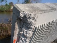
For nearly three months I have not ventured beyond 100 miles of New Orleans, so taking a trip somewhere not looking like a bomb went off or somewhere not choking to death with evacuee-related traffic (i.e. Baton Rouge or Houma) sounded appealing for the Thanksgiving holiday. Less than a four hour drive from New Orleans, Vicksburg fit the bill for what was needed. All of the touristy things were done in Vicksburg--the Vicksburg National Military Park (I scoffed at my father for buying the drive tour CD at the Visitor's Center, but it was actually a damn good accompaniment to driving the battlefield), the private Vicksburg Battlefield Museum in a building built to resemble a Civil War-era Ironclad ship that more looks like it should be an adult book/video store, the re-assembled USS Cairo (an ironclad ship sunk during the Civil War salvaged from the Yazoo River), and of course the all-you-can-eat Thanksgiving casino buffet--soft serve ice cream and sprinkles included. (The Illinois Memorial at the VNMP is seen in the picture above.)

The subject of New Orleans did come up with several people I had contact with over the weekend. A man from Kansas told me: "No offense--but I am against spending a single dime on that city in its current location. Move everything up to higher ground." And then a guy from Atlanta argued with me that "Bourbon Street had at least three feet of water--I saw it on the TV." Both of these illustrate what we are up against. The first guy (and he was cordial and polite) had a complete indifference to the city's uniqueness or culture or contributions to the world and was completely ignorant towards New Orleans' geopolitical importance on a global scale because of its location. The second guy, more disturbing than the first in my opinion, was just flat out misinformed or misinterpreted what he saw "on the TV" or was collectively describing New Orleans as Bourbon Street. Whatever it was--ouch. Of course the national coverage of this whole KTMB thing was/is just pathetic--its no wonder why outsiders could be so clueless. I did however get a few "if we can spend all of that money in Iraq, why can't we spend it on our own soil" responses from others as well . . .

The book RISING TIDE: THE GREAT MISSISSIPPI FLOOD OF 1927 AND HOW IT CHANGED AMERICA tells the story of the Great Mississippi River Flood of 1927 from the perspective of New Orleans and Greenville, Mississippi. The book was a big hit when it came out in the late 1990s, and interest in it has again peaked given the recent flooding of New Orleans. I personally have seen author John Barry on television numerous times since August and he has become the resident flood history expert trotted out on national cable news. I had never been to Greenville, and its location 90 miles from Vicksburg was too close to not visit. With my copy of RISING TIDE in hand (of which I've recently re-read certain chapters), we made the pilgrimage to Greenville. On the way up there however, we crossed the River at Vicksburg and drove on the Louisiana/Arkansas side to get to Greenville. In Lake Providence, Louisiana, we stopped at the local tourist information center located in an old Victorian house on the edge of town. There we met the stereotypical nice old lady who works at the local tourist information center who showed us vintage photos of the town including the steamboats at its landing before the "new" (post-1927) levees were built. On the oxbow lake--from which the town gets its name--across from the visitor's center is a boardwalk that provided great views of the lake and the masses of autumn-colored cypress trees. My wife bought a cookbook put out by a local church so now we can fix enchiladas Lake Providence-style. Lake Providence was a pleasant surprise.

We continued north through the cotton fields into Arkansas, passing through the Town of Eudora, and then back across the Mississippi River into Mississippi and the City of Greenville. After a brief stop at the Mississippi Welcome Center where I was questioned if I "was actually going back to New Orleans to live," we drove into Downtown Greenville. The Downtown is relatively intact with many of its older buildings remaining, but like many towns of its size in 21st century United States, many buildings sit unused or certainly they could be described as underutilized. We ate lunch at Shotgun House BBQ on Central Street and the owner of the restaurant told us stories from the 1927 Flood passed down from family who lived through it. Unfortunately, the few museums located Downtown were all closed--so that was a disappointment. However, as we drove along Main Street from Downtown to the grander residential areas of the city, we happened upon the McCormick Book Inn--an independent bookseller similar to Octavia Books or Maple Street Books or Garden District Book Shop in New Orleans. Because of the impressive list of authors hailing from the city, Greenville has been acknowledged as Mississippi's literary center and logically the bookstore did not disappoint. The back room of the McCormick Book Inn houses a fantastic collection of photos and newspaper clippings, etc. of museum quality and presentation which I have no doubt eclipses or is equal to any other collection regarding Greenville and the 1927 Flood that might exist anywhere. Furthermore, the conversation I had with the store's owner regarding the 1927 Flood, Greenville, New Orleans, and RISING TIDE alone made the trip worthwhile. In the beginning of our conversation, he asked me point blank, in an incredulous tone why I was in Greenville--and I replied "I think it was to talk to you . . . " One thing I was interested in was how deep the water got at Greenville and I was told that on average the water was about four feet deep (in some places depending on the topography, a bit deeper).

After exploring some areas of Greenville recommended at the bookstore and a quick visit to the Town of Leland (boyhood home of Jim Henson), we got onto US 61 and headed back down to Vicksburg. It was a fantastic day-trip that exceeded my expectations.

24 November 2005

New Orleans Carnival 2006 Sponsored By Wal-Mart


City administration officials announced the eight day parade plan for Carnival 2006. Although the expanded parade schedule gives all of us who love Carnival in New Orleans something to look forward to and plan for, the city has also asked for corporate sponsorship to defray the costs of the expanded schedule. Instead of first asking for volunteers from around the U.S. to come and help New Orleans for Mardi Gras 2006, the city immediately turned to the corporate world to solve our financial problems. Police, fire, garbage and other service employees from around the U.S. would have likely volunteered their time and equipment to come and help New Orleans pull off a full Carnival season this year, if asked. Instead we are going to forever alter the character of Mardi Gras in New Orleans by reaching out to our good corporate friends. I can't wait for Wal-Mart, Home Depot, ExxonMobil, CocaCola, AnheuserBush, etc. to get their hands on Carnival. I am sure the highlights will be banners on floats such as Bacchus brought to you by Trojan Condoms! and Tucks sponsored by Tucks!

If you doubt the amount of change that could take place from corporate sponsorship, just turn on the Macy's Thanksgiving Day Parade and listen to Al Roker read off all types of corporate dribble as floats pass by their reviewing stand. It is pathetic and it could be our future.

There is still a chance. To our city officials: Admit you made a mistake by suggesting corporate sponsorship can solve our problems this Carnival season. To everyone that loves Carnival in New Orleans: Write, call, and email people you know in other cities throughout the U.S. and start spreading the word that New Orleans needs volunteer police, fire and garbage workers for Carnival this year. The message we would truly be sending to all: Our traditions are not for sale at any price!

23 November 2005

Mardi Gras & Tourism are Economic Stimuli

In recent weeks there has been a lot of debate about Mardi Gras. Should we have it? If so, should it be a shortened version? Earlier this week, the New Orleans City officials announced that Mardi Gras will be shortened to 6 days. Krewes that run before the Thursday before Fat Tuesday will be out of luck. They say that there is not enough money in the Police Department to pay for the overtime needed.

But it seems to me that if you cut Mardi Gras short, then you deny the city millions of dollars of potential tax money. Hotels, restaurants, entertainment, shops, and bars all generate millions of tax dollars that pay for police, fire, and other city services that are needed for such large crowds. If Mardi Gras is allowed in full then the money will eventually be in the system to pay for the police. Mayor Ray Nagin is a business man, and any good business man knows that you need to spend money to make money.

However, if city officials are worried about the current budget(pre Mardi Gras) then they should develop a comprehensive plan to get the tourists back. This can easily be done through advertising in other cities. Have commercials play during nationally televised College bowl games announcing that New Orleans is "Open for Business". First, Thank Americans for their support during and after Hurricane Katrina. Then tell them that the French Quarter and Scenic Uptown are back in swing and that Mardi Gras will be in full force. Promise them a great time with the music and culture that can only be offered here. Ask them to visit our great city to see what they have helped save through their donations. Make America feel like a part of New Orleans. If this is done then tourists will come and money will again flow into the local economy.

However, there are some alternatives for police support if the budget is slim: Ask the Governor to relocate State Police as was done back in the 80s when the NOPD went on strike. Or ask police from other cities that donated their time for hurricane Katrina to come back down to New Orleans and help out. Guarantee them room and board and 1 day on and 1 day off so they can enjoy Mardi Gras first hand. What cop wouldn't take that offer?

The answers to solving the Mardi Gras dilemma are out there. They Mayor just needs get motivated and find them.

CBS 60 MINUTES and the So Called Experts

I wasn't going to address the CBS 60 MINUTES thing because I didn't want to waste any time responding to such drivel but, I can't stand it. First 60 MINUTES .......

It is obvious 60 MINUTES aired it because it was a far out opinion not because "they wanted to present a side of the story that hadn't been heard." Experts in the coastal evnvironments have never heard of Dr. Kusky. The only thing he has ever written on the subject was an OP/ED in The Boston Globe that Donald Boesch (native New Orleanian and President of Coastal Studies at the University of Maryland) said "reads like an undergraduate paper". It is very disappointing that 60 MINUTES would use and "expert" that so clearly has little expertise in the area he is talking about.

What about Dr. Kusky's opinion? Abandon New Orleans? Has he thought about this at all?

Does he think that everyone should move from coastal California too? It is possible it could fall into the Pacific. What about Florida? They will continue to get hammered by hurricanes. I think Mr. Kusky should seriously consider moving from St. Louis. As a geologist he knows about the New Madrid Fault. It's predicted they will have a major earthquake within 50 years. That could change the course of the river and screw the whole Mississippi Valley. While were at it let's just evenly spread out our population over the entire lower 48. That would lessen the impact of another terror attack....................in short its ridiculous. The location of New Orleans is unfortunate but necessary. It is necessary economically, politically and strategically.

How would Dr. Kusky feel about it if he was told he had to move from his home? Probably not that big a deal to him. Most other places are just places to live, not very different from any other. New Orleans is a home. That is one of the many things that makes it special. As Chris Rose wrote in the TP yesterday "the longer you live in N.O., the less fit you are to live anywhere else."

We may have lost a few parts but, we haven't lost our heart. That is why it doesn't matter what people like Dr. Kusky say.

New Orleans-Proud to call it home.

THE THIRD BATTLE OF NEW ORLEANS Subdomain Name Change . . . .

The subdomain name of THE THIRD BATTLE OF NEW ORLEANS has changed. It is no longer krewechardeguerre.blogspot.com but now thethirdbattleofneworleans.blogspot.com. I think this makes the site name easier to remember and easier to pass out. Explanation of Krewe Char de Guerre coming soon . . .

Photo du Jour: Irony, 30 September 2005


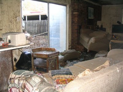
On the morning of Saturday, 27 August 2005, I went over to a friend's house in Lakeview and we sat and talked in the room pictured above . . .

KTMB had drenched South Florida the weekend before and all throughout the week the consensus on all of the local television stations (especially WVUE/Bob Breck) was that KTMB was going to come ashore to the east on the Florida Panhandle. The Saints played the Ravens on Friday night in the last home preseason game which I attended. After the game concluded, the WWL radio broadcast had a special weather announcement to make: uh oh--unfortunately there had been a big change regarding KTMB. When I drove over to my friend's in Lakeview the next day, there was a tension in the air/on the road similar to days before what turned-out-to-be near misses of New Orleans during Hurricane Georges in 1998 and Hurricane Ivan in 2004. When I got to my friend's house, the subject of conversation naturally was the hurricane and what everyone's evacuation plans were. In that conversation, the flooding potential came up and the question was asked to me, did I think it could flood in that house. My response, "only if a levee breaks or the water overtops the levees . . ."

The irony of this is that I said this while sitting in the exact spot on the sofa where that day's Times-Picayune with the headline KATRINA TAKES AIM came to rest following the eight to ten foot inundation within the house. The sofa of course is five feet out of place because it floated (along with all of the furniture within the house) and then came back down to the floor once the waters receded. The sliding glass door apparently exploded from the pressure of the water inside the house. The good news for my friend: his house is two stories and for the most part everything upstairs was unscathed. At least hes got that--many with one story houses don't even have that luxury.

21 November 2005

Photo du Jour: Metairie/Lakeway Center


New Orleans prides itself for its long-time locally owned businesses. Although many have been bought out or merged with existing companies over the years (i.e. K&B, Schwegmann's, D.H. Holmes, etc.), we still have proportionally more still around than most cities. A fact of life in this country in the 21st century is the convenience and perceived need for the so-called national chain "big box" retailers. The Southshore "big box" retail stores predominately cluster in one of three areas: the Jefferson Parish Eastbank (Metairie/Kenner/Elmwood), the Jefferson Parish Westbank (Gretna/Harvey), or within the City of New Orleans in New Orleans East. (And of course, those stores located in New Orleans East are out-of-commission for the foreseeable future, and maybe forever.) For many that live within the City, the stores located in Jefferson Parish are physically closer and easier to get to from their homes than the stores within the city boundaries in New Orleans East. The reality is that the "core" city (City of New Orleans from the 17th Street Canal to the Industrial Canal) has very few tracts of undeveloped land sizeable enough for such development. Furthermore, the scale and preferred makeup of such buildings do not fit the relatively dense urban composition and architectural context of the "core" city (City of New Orleans minus New Orleans East and Algiers). In the past few years, two big box stores were built within the core city--a Lowe's on Elysian Fields Avenue and a Wal-Mart Supercenter in the Lower Garden District. The introduction of Wal-Mart to Uptown New Orleans received significant opposition from preservation-minded citizens and small business owners, but was built anyway despite this. Supposedly The Home Depot is (at least, prior to KTMB) planning to build a new store along the Pontchartrain Expressway near Jefferson Davis Parkway/South Claiborne Avenue, but that project has been hush-hush pre-KTMB and post-KTMB. A new Lowe's appears to still be under construction post-KTMB on Jefferson Highway in Jefferson Parish right at the city boundary setting up yet another case of proximity to the city, but tax dollars all going towards the suburban parish and not the City.

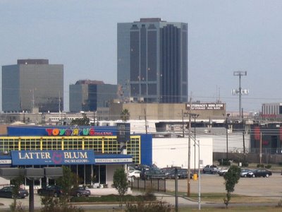
Blah, blah, blah . . . With that, the picture above was taken Sunday from the rooftop parking area at the Lowe's on Veterans Boulevard in Metairie. The blown-out windows of Lakeway Center can be seen in the distance--the other side of the building facing Lake Pontchartrain sustained even more damage. The majority of the national retail stuff in Metairie is now open, although some remain closed as they are still being repaired.

Profit Before Protection

A house bill to combine several levee districts was killed in the special session yesterday according to the TP today. The bill consolidated boards all around New Orleans but, left the New Orleans board alone. Why? Who are they scared of?

The Orleans Levee Board is a joke. They have their own police force for Pete's sake!! Is that really necessary? They own an airport and two marinas. They spent 2.5million dollars on a fountain. Spent millions getting overpasses built so they could lease land to a casino that now funds most of their projects. So what do they have to do with the levees really? Does anyone on the board have any expertise in the area of levee protection? No. Why you may ask? Because they are for profit before protection............

Here's a quote..........

October 27, 2005 ... "As long as any flood control or hurricane protection work is left undone, I will reassess any project not directly related to those objectives. For the levee board to spend money on other projects can pose a grave danger to residents of New Orleans." --William Nungesser, Former Orleans Parish Levee Board President, 22 April 1996.

Mr. Nungesser was replaced.

Sell off the assets of the levee board, dissolve it and put experts in control of our hurricane protection systems. We knew it was happening and it was still allowed to go on. We are all to blame for falling asleep at the wheel. I hope being held underwater for three weeks woke us all up.

20 November 2005

The Urban Land Institute Recommendations


Map Source: The Times-Picayune, 19 November 2005

The Urban Land Institute, a internationally recognized non-profit organization/"think-tank," released its recommendations for New Orleans' rebuilt future on Friday following a week-long symposium by fifty of its experts (LINK). The ULI produces publications, plans, papers, etc. regarding urban development strategies, issues, etc. and generated the Canal Street revitalization plan a few years back for the New Orleans Downtown Development District (DDD). Local developer Joe Canizaro is a big proponent of the ULI and is a past-president of the organization. Press Kabacoff, another local developer (who has taken a lot of heat recently because of the River Garden development--a mixed-use development in the Lower Garden District which replaced the St. Thomas Housing Project that includes a Wal-Mart Supercenter), received the ULI Visionaries in Urban Development Award in 2004.

The Times-Picayune's coverage of the plan can be found here: (LINK).

19 November 2005

Photo du Jour: The Dixie Brewery


Ever since KTMB, every now and then there is some building or some place in New Orleans that all of the sudden pops into my mind that I forgot completely about that based on its location I know got a ton of water. The latest example of this for me was the Dixie Brewery on Tulane Avenue. I don't recall hearing anything about what the status of the 98 year old brewery post-KTMB but a quick google query retrieved this. It says the owners plan to return--so thats good to hear. You know, maybe they should just relocate the operation to that hurricane free zone of Orlando like Ruth's Chris Sellout. You know, it doesn't have to be IN New Orleans to be New Orleans as R'sC Sellout's CEO Craig S. Miller believes. (Sorry, couldn't help myself). The high water line in this area appears to be about seven or eight feet. Other well-known businesses in this area are Joe's Bike Shop, Bud's Broiler (the original one I think--the yellow building in the above picture), and Nick's (Original Big Train Bar) which is directly across the street from the brewery--oh, and a bunch old seedy 1950ish motels--which have amazingly mostly been gutted already.

18 November 2005

Photo du Jour: Welcome to Lakeview


The New Basin Canal was dug in the 1830s and provided access from Lake Pontchartrain to the Faubourg St. Mary (the CBD) culminating with a turning basin at the current Louisiana Superdome site. Thousands of Irish immigrant laborers died during construction of the canal because of yellow fever and cholera epidemics that swept the city. The canal was filled in the mid-20th century and I-10 from the I-610 split to South Claiborne follows its former path. Towards the Lake from the I-10/I-610 split, the former canal is the most expansive neutral ground (median) around dividing Pontchartrain (riverbound) and West End (lakebound) Boulevards for a distance of almost two miles. The New Basin Canal Park is mostly undeveloped green space with a fair amount of trees, a bike path, and a monument to commemorate the Irish that died when digging the no longer existing canal.

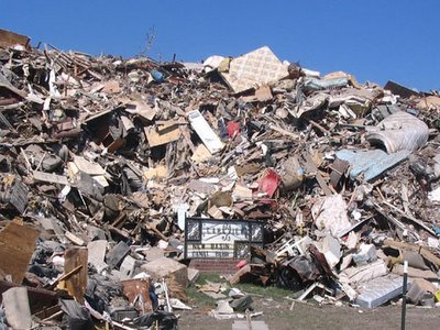
Because of its sheer openness and its central location, parts of this space are being used as dump-off and staging area in the removal of the tons and tons of ruined things created from the KTMB flooding. Every everyday thing and household item imaginable can be seen in this pile that two weeks ago (when this picture was taken) was over thirty feet high. Standing next to this really brings home the severity of the situation and the amount of loss incurred from this disaster. Toys, stuffed animals, bikes, coffee makers, mattresses, books . . . And the Lakeview neighborhood sign just sits there being engulfed by all of this stuff. Behind this pile towards Harrison Avenue sits another large heap dedicated to organic debris such as tree stumps and limbs. Similar mountains of tree debris can be seen out in Metairie at Lafrenier Park.

17 November 2005

Photo du Jour: San Antoleans


At least 100,000 New Orleans/Louisiana KTMB-displaced citizens are currently residing in Houston and other Texas cities. Essentially, the federal government is subsidizing significant portions of our population to not return back to Louisiana by providing rent-free housing for a year in Houston. They have no incentive to ever come back to New Orleans and all the government-sponsored incentive in the world to remain in Texas. And in some cases their New Orleans homes weren't impacted by the flood waters, but in their eyes they'd be absolutely stupid not to take advantage of a rent-free apartment in Houston. Not only do we lose population and potentially federal representation because of this policy (Louisiana will likely lose another electoral vote/U.S. Representative after the 2010 Census--which may or may not have happened anyway, but the KTMB exodus won't help), but we lose a vital part of our heritage and culture as our citizenry is dispersed from our city and state.

So what does all of this have to do with the above picture of the traffic signals at the South Carrollton/South Claiborne Avenue intersection taken this morning? I just thought it was ironic that we give Texas our people and for some strange reason we get their goofy sideways traffic signals (except for the turning arrow ones). These were installed since KTMB as I think its safe to say the old signals were probably damaged in the floodwaters and the horizontal Texas standard was applied. Whats next--we refer I-10 as IH-10 now???

16 November 2005

Then and Now--And Then: North Claiborne Avenue and Deslonde Street

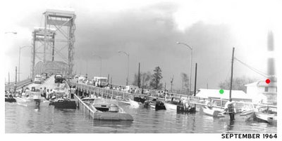
Last week I stumbled upon a slew of post-Hurricane Betsy photos on a St. Bernard Parish Government-run website. (LINK) The storm surge of Hurricane Betsy caused catastrophic damage in September 1965 in many of the same areas impacted by KTMB such as the Lower 9th Ward and St. Bernard Parish. One of the pictures I thought was especially interesting was taken (from a boat I presume) in the flood waters at the base of the North Claiborne Bridge looking back towards the bridge. Upon seeing that 1965 image, I brought up the before (2004) and after (2005) KTMB oblique shots taken by Pictometry to contrast and compare the area before and after the storm, but also to see the differences from 1965 to now. The yellow dot on the above 2004/2005 photos represent the location or point of view where the 1965 photo below was taken. The red and green dots signify the locations of the same two buildings in all three time periods. Post-KTMB, the green dot house is no longer there. Based on the distance of the water level up the slope of the bridge from its base in both the 2005 and 1965 photos, it appears the severity of the flooding was virtually the same. As the forty year old photos illustrate, to even suggest "we had no idea this could happen" is absolute uninformed nonsense.

Comments? Ideas? Email seymourdfair@gmail.com.

The Richard Campanella Methodology: A Sensible Approach Towards the Reconstruction of NOLA

I have been a fan of Richard Campanella's work in his two books New Orleans Then and Now and Time and Place in New Orleans: Past Geographies in the Present Day. Both of these books are fantastic and extremely well researched and presented--and in the same league as the 1970s Pierce Lewis New Orleans: The Making of an Urban Landscape classic. These books are a must . . .

In Sunday's "Other Opinions" section of the Times-Picayune, Mr. Campanella, a geographer with the Center of Bioenvironmental Research, proposes a scientific methodology to aid in the reconstruction process of New Orleans. As he states at the end of the piece, he doesn't believe his proposed methodology is the end-all be-all, but he does manage to put on paper a rational approach which in some form should be applied. Building an inventory and determining status of individual blocks (preferably) or census tracts is a no-brainer towards understanding the big picture and developing a comprehensive plan to move forward. Inventory then analysis leading to the design or plan--any first year design student can tell you this.

Heres his plan:

Blueprints: Visions for Rebuilding/Finding a Way Out of Devastation

Authored by Richard Campanella
Times-Picayune "Other Opinions"
13 November 2005

New Orleans is facing some colossal decisions. Should certain neighborhoods be demolished or rebuilt? What if residents want to return but engineers recommend against it? What if the housing stock is severely damaged, but historically and architecturally significant?

Every New Orleanian, from layperson to professional, has ideas on how the city should be reconstructed. What has been lacking is a sound, straightforward methodology through which these ideas may be passed, so that difficult decisions may be made fairly and consistently.

As a geographer and long-time New Orleans historical researcher, I would like to suggest a plan.

It is based on one overriding principle: that the best decisions are based on solid, scientific data rather than emotions or politics. But any reconstruction methodology needs to balance four fundamental (and sometimes conflicting) values:


  • All New Orleanians have the right to return to their city, and if possible, their homes.
  • Homes must be structurally safe.
  • The historical and architectural character of the neighborhoods must be maintained to the utmost degree possible.
  • Neighborhoods must be safe as possible from future floods, contanaminants and other threats.


Here's the methodology:

Step 1: Determine who wants to return. Survey residents (both returned and evacuated) regarding their intent to live in New Orleans in the future. Record the respondents' pre-Katrina addresses, and map out the results by census tract. Code red those with the lowest return rates, under 25 percent; yellow those with return rates of 25 to 50 percent, and green those with return rates of 50 to 100 percent.

Step 2: Determine structural safety. Code red tracts with over 75 percent condemnation rates, yellow those with 50 to 75 percent condemnation, and green those with under 50 percent condemnation.

Step 3: Determine historical and architectural significance. Once again, code red those tracts deemed to be historically or architecturally least significant; yellow those deemed fairly significant, and green those deemed highly significant.

Step 4: Determine environmental safety. Code red tracts that are determined to be well below sea level and highly vulnerable or contaminated; yellow those near sea level and somewhat vulnerable; and green those above sea level and relatively safe.

Step 5: Map out the results of all four surveys by census tract. Now we know the geography of our problems, and where we need to focus our attention. Tracts coded green in all four surveys are safe, historic areas to which residents want to return. They will rebound on their own.

On the other hand, tracts coded red in all four surveys are dangerous, heavily damaged, non-historic areas to which residents mostly do not want to return. Sad as it is for those few who do, it is not worth the tremendous societal effort to rebuild in these unsafe areas. They should be cleared, and returned to forest, to serve as flood-retention areas, green space and wildlife habitat and Katrina memorial parks. And former residents who desire to return should have first crack at renting or buying parcels in nearby areas.

What about neighborhoods that are more a mixed bag?

Tracts coded yellow or green in the resident-return survey but red in all other surveys--in other words, where most people want to come back despite severe damage and potential danger-should be cleared and rebuilt more safely, simply because a significant number of residents demand it.

Conversely, neighborhoods that are high in architectural or historical value should be saved to maintain our city's character and tourism economy, even if returning residents are few and the risks are high.

Perhaps the surveys should be done by blocks, or by the 70-odd official neighborhood boundaries, rather than by census tracts.

Admittedly, certain elements of my methodology are subjective, time-consuming, costly, susceptible to abuse and overly simplistic. My proposal does not address important engineering issues such as levee reinforcement or coastal restoration. But it is a sensible approach to the mending of the city's urban fabric.

Whatever methodology is chosen, it should balance fundamental values and be easy to communicate to the public. I offer my "road map" not as the one and only possible methodology, but merely in the hope of convincing the powers that be of the need for one.

15 November 2005

Photo du Jour: Ted's Frostop


Saturday afternoon I made it over to the commerical district at South Claiborne Avenue and Calhoun Street (and South Miro Street) across from Tulane University. There is a mix of businesses in this area including several restaraunts, a bar, a cleaners, and a strip shopping center with a Circle K and Blockbuster Video. The flood line on the walls here reaches two to three feet. What I saw in this area was encouraging: the interiors of most of the businesses have been gutted and some have already hung new sheetrock. Bud's Broiler, Mona's, Ted's Frostop, Bayou Bagelry, Papa John's, the strip shopping center, the cleaners, and Robert's Bar are in the reconstruction phase now. Robert's Bar especially seemed to be moving along really well. I look forward to drinking my first shot glass-like beer there when they re-open. Some of the other establishments like Kokapelli's remain in the clean-up phase a bit behind the other places. Later in the day, I stopped by Five Happiness on South Carrollton. The interior there has been completely cleared out and the owner intends to be open within five months.

Geography du Jour: Flood Depth/Extent, 3 September 2005


The above map (areas within the black boundary lines) illustrates the peak depth and extent of the KTMB-related flooding in New Orleans, Old Metairie/Old Jefferson, and Upper St. Bernard (Arabi/Chalmette) on 3 September 2005. The data was generated by NOAA applying the modeled levels of the storm surged Lake Pontchartrain/drainage canals and the Mississippi River Gulf Outlet (MRGO) and overlaying it with a LIDAR-generated elevation model. The differences between the ground elevation and the peak water level is the depth value thematically displayed on the map. The areas where the satellite photography is visible are the locations not inundated becasue of the floodwall/levee failures. The water depth progression ranges go from red (the shallowest waters) to orange to yellow to green to blue (the deepest waters).

14 November 2005

Photo du Jour: Oak Trees Hate Streetcars


Still awaiting word from the Regional Transit Authority on the return of the Streetcars post-KTMB. . . Saturday afternoon the crack Krewe Char de Guerre team did an impromptu survey of the overhead electrical wires and poles along a good portion of the St. Charles Avenue Line. Several city block-long sections have downed wires and bent-up overhead poles--including near Audubon Place and from Jefferson Avenue to Soniat Street in front of the Latter Library. The worst downed wires appear to be at the Calhoun Street intersection where the Upriver-bound feeder wire blocks the crossover. In some cases falling limbs damaged the lines and/or poles and in other cases entire oak trees collapased upon them such as at Calhoun. Why do the oak trees hate the streetcars?

Build It and They Will Come . . .

Let me start by saying I am just writing this off the cuff and I know that the Saints will win the Superbowl before it happens.

Lets just build the freakin' levees. Everyone keeps asking when is the federal government going to realize how valuable we are and pay for our levees. All we need is 14 billion over 10 years is what they say. I say we build them ourselves. 14 billion dollars over 10 years equates to 700 dollars per household in Louisiana per year for 10 years. (based on roughly 2 million households in the state) that's a lot for some people you may say. Yes, it is. Consideration would be given to that. Include corporations in the mix and individual household responsibility would go down. There are options..................This is possible if we make it happen. How bad do we really want it? Desperate times call for desperate measures...........I'd write my first check today.

13 November 2005

Photo du Jour: The FEMA Fortress


Flooding is no stranger to New Orleans. KTMB has obviously redefined what catastrophic flooding is, but New Orleans has quite a history of some doosies. Take the house located near Napoleon and South Claiborne pictured above for instance. Sure is raised up high, isn't it? On the evening of 9 May 1995, nearly 20 inches of rain drenched portions of the city. Naturally, the pumps and the canals could not handle this volume of water and extensive flooding occured in certain areas including this house location. The "May 9th Flood" remains FEMA's most paid out flood event (prior to KTMB) in the history of the country as over 31,000 properties recieved flood insurance monies to cover flood-related damage. Because the house flooded a few times before May 1995 it was catagorized as a "repetivtive loss" property and qualified the home for participation in an optional FEMA house-raising program. The owners decided to participate in the program, and the picture above shows the result of an insanely raised house. The good news: the 7+ feet of floodwater did not penetrate the main portion of the house, but instead only the concrete block unfinished basesment/garage. The bad news: the absolute rigamorole the owners had to endure at both the federal and local government levels for over ten years (the house was three weeks shy of being completely finished when KTMB showed up) to get the job done. Oh, and the the 30k FEMA provided to raise the house--not even close. More bad news: all of the owner's belongings were not yet moved into their mongo raised house, but instead were in a rental basement apartment across the street. As bad as all of this sounds, the owners are amazingly among the most die-hard stick it out New Orleanians I have run into post-KTMB.

12 November 2005

Lies and Secrecy: How Our Senators Plan On Rebuilding New Orleans


Louisiana's U.S. senators Mary Landrieu and David Vitter recently proposed a bill that would create a committee to oversee the U.S. Army Corps of Engineers' projects to rebuild New Orleans' flood control infrastructure. A large part of this bill would exempt future federal projects implemented under this committee's control from existing environmental regulations, specifically the National Environmental Policy Act (NEPA) and the Clean Water Act. Foolishly, our senators, as well as our former U.S. senator J. Bennett Johnston, have told congress and others that environmental regulations are responsible for the flooding of New Orleans and that these regulations have led to a lengthy process of providing adequate protection.

Of course, none of this is true. NEPA and the Clean Water Act regulations are largely procedural and their main purpose is simply to describe a project to the public in layperson terms and disclose the potential impacts of that project on the human and natural environment. That is it; these regulations do nothing else. They cannot stop, change or even slow a project; only public input as a result of disclosure is capable of doing those things. Typically projects only get slowed or stopped by environmental regulations when the actual proposed action and its impacts are disclosed, and the general public becomes outraged by the likely outcome of the proposed project. Many projects built before these environmental regulations (e.g., Mississippi River Gulf Outlet) so outrage the public that the public often cannot understand how they ever got built. So, if you are a politician and you don't like your constituents meddling in large projects with big dollars (and contracts) involved that could, and likely would displace people, destroy historic and cultural resources, alter aesthetics and harm fish and wildlife resources, you naturally want to waive the "problematic environmental laws" because these laws would force public disclosure of federal actions.

Levees in New Orleans did not fail because of environmental regulations. Obviously having to write an Environmental Impact Statement for the 17th Street Canal flood protection improvements did not lead to its failure during Katrina. Only bad designs or poor construction are capable of causing levee/floodwall failure. Flood protection projects for New Orleans previously proposed by the U.S. Army Corps of Engineers that would have provided greater levels of protection then New Orleans had at the time of Katrina were not stopped by environmental regulations, but instead were stopped by inadequate funding by the same congressional leaders who now want to waive environmental regulations for similar projects.

In the rush to provide adequate flood protection for New Orleans, make sure you ask yourself a simple question: Do you trust your local, state and federal agencies, and elected officials to create and implement the perfect projects without any public disclosure of what those projects will be or what level of impacts they will have? If environmental laws such as NEPA and the Clean Water Act are exempted for future projects, hundreds of millions to billions of dollars will be spent on projects without your input, and resources that are important to you and your family will likely be destroyed without your knowledge. There is nothing like those type of secret dealings to truly make you feel like a Louisiana resident.

11 November 2005

Photo du Jour: Eddie Bo Performs at Mid City Rock N Bowl KTMB +72


Mid City Rock N' Bowl reopened last night with 75 year old piano legend Eddie Bo headlining. As he was introducing Eddie Bo on to stage, owner John Blancher stated that MCRnB will be open as long as he is alive. No word however on his other South Carrollton Avenue longtime-established Ye Olde College Inn. Ernie K-Doe's widow Antoinette was also on hand to announce she has all intentions of reopening the Mother-in-Law Lounge in Treme. The turnout was excellent and Rockin' Dopsie was on hand to do a few songs as well. There were no visible signs of obvious damage upstairs at MCRnB, but downstairs on the ground level of the building is a different story. Thrift City has been cleared out, but the Union Supermarket remains in very bad visual condtion--and it doesn't smell very good either. Water line marks on two Thrift City delivery trucks marooned in the parking lot reveal the 6+ feet of water this part of Mid City suffered. Once-submerged cars and trucks parked on the South Carrollton neutral ground, parked there by their owners before the storm to escape the anticipated KTMB street flooding, still remain abandoned between Tulane Avenue and Canal Street.

NOLA's Future Is Predictable But Can Its Course Be Changed?

This disaster did not have to happen. The magnitude of Katrina's impact is staggering and the effects will be felt locally and regionally for decades. Over 1,000 people reported dead in New Orleans, potentially a million people displaced, tens of thousands of structures in New Orleans damaged beyond repair, and now the economic losses are just starting to be realized. The Port of New Orleans is slow to recover, a record U.S. trade gap in September and the state of Louisiana is cutting vital programs to meet a $1 billion budget shortfall (soon to balloon with the required repayments to FEMA). Beyond the statistics remains the potential loss of a culture, damage to a historic jewel and a total disruption to a unique way of life. This all could have been prevented.

Most of us know the famous quote by George Santayana: "Those who cannot learn from history are doomed to repeat it". The focus of post-Katrina news coverage was on hurricane response. Although poorly planned and implemented, the lack of adequate hurricane response pales in comparison to the lack of planning to protect New Orleans from a predictable event. Since the early 1990s federally-funded research conducted by LSU and other academic institutions has predicted this event and its outcome. These studies have been presented to local, state and federal agencies responsible for flood protection in New Orleans. These studies have been presented to congressmen, and state elected officials for the past 15 years. In 2001 the Times-Picayune consolidated information from these studies, conducted in depth interviews and analyses and reported a series about the potential effects from this disaster. Dr. Ivor van Heerden, director of the LSU Hurricane Center has made accurate predictions of this disaster for many years (http://hurricane.lsu.edu/_in_the_news/april21_advocate.htm). But the news media has made very little noise about this fact, and government officials have said very little about their involvement in this lack of planning.

This story gets worse. The 1927 Mississippi River flood is considered to be, until Hurricane Katrina, the single most devastating natural disaster to strike the U.S. The total number of dead from the 1927 flood is not known but it was likely in the thousands. Approximately 700,000 people were displaced by flooding of 27,000 square miles of land. The 1927 flood changed the political, demographic and economic landscape of the U.S. Herbert Hoover, then Secretary of Commerce, became famous for his lead in the relief efforts which led to his being elected to the office of the President in 1929. So who cares, right? That was 1927, not 2005 and cannot possibly be relevant to today's situation.

The failure of the levee system leading to the 1927 Mississippi River flood was a predictable event and had been predicted by numerous engineers. Those in power in government agencies and elected politicians refused to listen, the disaster was not avoided and the focus of the times following the disaster was on relief. Changes were eventually made to flood control measures on the Mississippi River, but only after a massive loss of life and near economic disaster for the U.S., none of which had to happen.

How about another watershed event for the U.S.? For years prior to September 11, 2001 the U.S. government was warned about the possibility of a terrorist attack on the U.S. The 9-11 Commission Report clearly outlines all of the opportunities that were provided to the U.S. government to thwart the attacks. Of course, the attacks happened, a tremendous loss of life was involved, it has completely change the way Americans live their lives, how govenment funding is appropriated and has led to wars in two distant countries.

Back to the present. These two simple past examples of our elected officials and government agencies not responding to predictable distrastous events in advance are analagous to pre-Katrina New Orleans. There are other similar examples in our history. Even FEMA recognized a hurricane making landfall on New Orleans as being the single greatest natural disaster facing the U.S. Yet nothing was done. Past history tells us that inaction toward predictable events leads to massive disasters. Yet nothing was done.

Over 1,000 dead in New Orleans, a million people displaced, tens to hundreds of billions of dollars in damage - all of which was totally preventable with simple actions taken in advance. Do our elected officials that ignored the warnings and the heads of government agencies that did not spend money appropriately, or worse, allowed for poor quality construction of existing facilities, have any civil or criminal culpability for these damages? History tells us they do not, that we will learn nothing from this disaster and not work towards preventing future disasters.

Now let us predict the future (it is easy to do with history as your guide). Some people will become famous for their response to the disaster, and many will deserve the accolades. New Orleans will become a shell of its glorious past. The State of Louisiana's economy may never recover. The U.S. economy will take a major short-term hit, but will rapidly recover as money is spent on disaster relief. Hundreds of thousands of people will permanently relocate to other urban areas across the U.S. leading to a large-scale demographic change in our population. And finally, because our society elects people to power for their ability to respond to disasters instead of their ability to guide and protect people from them, politicians will continue to ignore warnings by highly educated individuals about potential disasters that could cause a major loss of life, economic disruption and cultural collapse.

However, it is not too late to change this course of events. It is time for our news media and thinking individuals in the community to pose hard questions to our politicians and agency officials about their culpability in this disaster. Those who ignored the clearly-stated warnings need to be held responsible. And most importantly, our elected leaders need to plan for protection and take steps to manage predictable events instead of patting themselves on the back for responding to preventable disasters.

10 November 2005

One Word: Ridges


1878 Plan of New Orleans and Surroundings. Why da ain't no streets in Broadmoor, Lakeview, Gentilly, or in Da East?

In The Graduate, Benjamin Braddock was told "plastics." In a particular Seinfeld episode, Kramer had his "levels." In the case of New Orleans, the one word is "ridges."

The lead article in the 3 November 2005 Times-Picayune (LINK) discusses the realization that the areas within the City of New Orleans that flooded because of the KTMB floodwall failures and those areas that didn't flood amazingly coincide with the bounds of New Orleans before 1900. The reason for this is not rocket science: the initial extent of the City of New Orleans was relegated to the higher ground of the locale's ridges. The surrounding near or below sea-level cypress and palmetto swamps (referred to as the "backswamps") remained undeveloped as they were subject to the annual Mississippi River Spring flooding as well as sporadic flooding from Lake Pontchartrain.

Since New Orleans' location is built upon the alluvial floodplain of the Mississippi River, the elevation is highest adjacent to the River than the land further from it. As the Mississippi River water receded following the annual Spring flood, the silt and sediment siphoned into the river from 1/8th of the North American continent formed natural levees on the lands adjacent to the Mississippi River. This pattern also occurred on secondary tributaries in the area forming the Metairie Ridge, the Gentilly Ridge, and the Bayou St. John Ridge. Because of the continuous flood threat, the city's development remained on the highest ground on these ridges for nearly 200 years. In the limited areas agreeable to urbanization the population of New Orleans capped out at about 200,000.

Two separate technological advancements by the 1930s allowed growth beyond the initial ridge extents: the invention of the mechanized pump in the early 1900s and the establishment of a formalized levee system in response to the 1927 Mississippi River Spring floods. The reclamation of the backswamp lands involved pumping out the standing waters and constructing a drainage system utilizing a network of canals. The river levees kept the Spring floods contained to the river bed and the batture lands riverside of the levees. Once these two elements were implemented, expansion beyond the ridges was deemed feasible and development in the non-ridge portions exploded--especially in the FHA/VA loan-induced years following World War II.

On 9 September 1965, Hurricane Betsy passed west of New Orleans causing catastrophic flooding in nearly all portions of coastal Southeast Louisiana including a yet-to-be-subdivided New Orleans East, the Lower 9th Ward, St. Bernard Parish, Plaquemines Parish, and the Lake Pontchartrain-bordered areas of St. Tammany Parish. (Sound familiar?) During the Hurricane Betsy event, the core of the City of New Orleans and neighboring Jefferson Parish suburban slab-o-rama were luckily spared the floodwaters. Hurricane Betsy however served as a wake up call and in the following years a hurricane-protection levee system was designed and installed with the goal of withstanding storm surge flooding from another Betsy-caliber hurricane. Until the early hours of 30 August 2005 the basis of that system kept the sea out of New Orleans for 35+ years.

Not only did the levees, the pumps, and the drainage canals allow expansion beyond the ridges, the vernacular architecture specific to "Ridge" New Orleans was abandoned in the majority of the post-World War II housing construction. In terms of the flood threat, the most important element of the vernacular New Orleans tradition was raised, off-the-ground houses on bricks or pillars. The international style of blah suburban ranch house, featuring brick construction on a concrete slab became the preference--especially after 1960. The new non-ridge houses should have been built-up even higher (in some cases ten feet above the ground level--on stilts or pillars) than the pre-1950 structures, but instead were built at ground level on a slab--in areas that were near or well below sea-level.

The ugly truth: the levees and the pumps and the drainage canals provide a false sense of immunity from the realities of the flood potential in the harsh geographic setting that is New Orleans. Some of Gentilly, nearly all of Lakeview, nearly all of New Orleans East, and nearly all of Chalmette are comprised of slab houses built at grade. The pre-1950's areas that did flood post-KTMB including most of Mid City, most of Broadmoor (literally translated as "large, poor draining land"), parts of Gentilly, parts of Uptown, and parts of Carrollton mostly consist of raised houses. Many houses in these areas did receive substantial (but salvageable) flood damage taking in 2+ feet of water (which could have been 5+ feet water if not for having been elevated), however many others in the ridge-periphery areas did not get penetrated by the floodwaters because of their elevated constuction. In some cases, six inches or less of elevation off the ground was the difference between a house flooding and not flooding. Another common issue is that over the course of the last 100 years many owners of elevated houses could not resist the urge of filling-in the open space underneath their houses to form additional space in a "New Orleans" basement (including the house I live in). Many homes with this feature suffered flooding in the basement but not the main space of the house revealing that there was a reason why that space was left open 100 years ago.

The slab-o-rama houses in areas below sea level by their design absolutely had no chance with this flood--end of story. Don't even get me started on the slab-o-rama in Jefferson Parish . . . Thats for another post.


Comments or ideas to share? Email seymourdfair@gmail.com.

Squirrels


I was listening to C. Ray's town hall meeting yesterday and just kept wondering if it was worth his time. I understand he wants his citizens to have access to him. He wants everyone to have a voice. He wants people to be able to air their grievances and try to get some answers to all their questions. He understands how frustrated everyone is and I commend him for that. However, what I heard yesterday was a waste of his time. He has an incredible job facing him right now. Listening to people rant on about the terrorists who blew up the levee or, how the new sound abatement walls along I-10 were really designed to channel water into black neighborhoods, is a waste of his time. I'm not making this up and I don't want to trivialize peoples losses. I know many lives are ruined and frustration levels are at all time highs but, there has to be a better way to have a town hall meeting. No real information came from the people that got to speak.

All I could think of was Buddy D. "The squirrels were out."

I'm glad Buddy isn't here to see the disaster that is the Saints right now. He loved them as much or more than we do. More on that later................

09 November 2005

Blessing or Disaster in the Making

Just read this from Nola.com :

WASHINGTON -- A Maryland congressman is urging his fellow Democrats to hold the party's 2008 presidential nominating convention in New Orleans as a signal of national support for the city after its devastating losses from Hurricane Katrina.

Rep. Elijah Cummings, D-Md., made the suggestion after party officials announced that their 2008 convention will be held Aug. 25-28. Declaring New Orleans as the host city for the party's national convention, Cummings said, would demonstrate to its residents that the city "has not been forgotten."


I thought this was a great idea until I saw the dates of the convention, smack in the middle of Hurricane Season and ending on the eve of the anniversary of the Katrina disaster. The is either a blessing or a disaster in the making. Republican Bobby Jindal is considering the same thing for the Republican Convention which was last held in New Orleans in 1988 without a hurricane incident.

08 November 2005

Photo du Jour: Flack Jacket Required KTMB +68


AB giving out some pregame love during the national anthem . . .

Tom Benson was sure smart not to take the LearJet from San Antonio to Baton Rouge to attend the Chicago Bears/Saints game this past Sunday. Tiger Stadium was like an English FA Premier League Arsenal v. Manchester United game with crazed drunken hooligans burning cars and setting the stands on fire--it was absolute chaos. Really, he and his entourage could have really been at risk being within 100 miles of there. Hell, I'm glad I wore my flack jacket and left the children home.

Of course I am being sarcastic . . .

The most threatening thing towards Mr. Benson I saw at the game? A guy holding up a banner with THE SIMPSONS Mr. Burns (equating Benson to Montgomery Burns--which is quite funny) which made a not so flattering comment about Mr. Benson eating things from his nose. In bad taste, yes. Life threatening, no. No such threats in Shangrila, I mean San Antonio, however.

The Hester Report


I saw another site that also posed--and answered--the question of the whereabouts of Sandra Hester of The Hester Report fame. LINK Only shown within the City (so the JP folks missed out), the show provided hours and hours of just flat out entertainment night after night pre-KTMB on one of Cox's Community Access channels. Her show primarily focused on denouncing the Orleans Parish School Board calling out people by name and calling them stupid, uncle toms, etc. Oh, and the fun with the blue-screen . . . I have a feeling THR will be back--look out FEMA. Look out Red Cross.

07 November 2005

Photo du Jour: I-10/I-610 Split, 27 August 2005--3pm


So we'll all take a weekend trip to Houston . . .

This picture was taken about 3pm on the Saturday afternoon before KTMB crashed the party--the westbound lanes are backed up towards Baton Rouge and the eastbound lanes towards the City are virtually empty. Westbound contraflow of I-10 had just begun about a mile and half from here at the Clearview Parkway interchange. The now infamous 17th Street Canal and entrance to the City of New Orleans is at the crest up ahead.

THE CREOLE TOMATO: Comic Relief, bruh

First there was THE ONION. Now there is THE CREOLE TOMATO. The Culinary Tour of Baton Rouge is especially funny. LINK

05 November 2005

Photo du Jour: Bay St. Louis KTMB + 66


The remains of a Bay St. Louis residence overlooking the bay. Nearly all structures within minimally 500 yards of the water now look like this.

I made it over to the Mississippi Gulf Coast yesterday to Diamondhead, Bay St. Louis, and Perlington. According to a Diamondhead resident, over 400 houses at Diamondhead were destroyed by the 25+ foot storm surge of Bay St. Louis and the Jourdan River. The Mississippi Gulf Coast includes three counties and runs along Mississippi Sound from Perlington (the mouth of the Pearl River) to Pascagoula--a distance of approximately 90 miles. Virtually all built structures adjacent to these 90 miles of coastline received catastrophic damage from the storm surge. As noted in an earlier post, the difference between the damage within the City of New Orleans and the "Coast" and Slidell and Lower Plaquemines Parish is strikingly different. In most cases in NOLA, buildings remain. In the coastal areas, many buildings are completely obliterated. The destruction of KTMB took a different form, but the end result is the same.

04 November 2005

Photo du Jour: Neon and Humvee KTMB +66


Veal Parmigiana. Eggplant Parmigana. Merlot. Abita Amber. Automatic weapon-toting National Guard Miliatary Police in desert fatigues with matching desert-camouflaged humvee.

Life in Uptown New Orleans in the areas fortunate enough not to have flooded has in alot of ways returned to normal--relatively speaking, of course. We made it out to a popular Italian place on St. Charles Avenue for dinner tonight and the place was jamming. Lots of people, lots of conversation--the food and the service were both excellent. Only one regular menu item not available (a shrimp dish) for the evening which in the NOLA post-KTMB restaraunt world is impressive as most places have extremely limited or in some cases fixed menus. So in this setting, with the swooning of Frank Sinatra in the background, all of the KTMB stuff is clensed from the mind and at least within the walls of this restaraunt its a normal Friday night. Then walks in a couple of National Guard MPs with weaponry in hand--and its remembered oh, ya, 80% of the place was flooded and is currently unihabitable and the assistance of the military has been necessary for the past three months to quell the situation. Back to reality--and for those that live upon the 20% spared high ground in the City, we remember for the 1,600th time since 4:30am KTMB +1 Tuesday how fortunate we are--almost to the point of guilt. And the cycle continues . . .

Cocks Communications

After moving back into my house once electricity had been restored to my neighborhood, I had patiently waited a few days before calling Cocks (Cox Communications) because I figured that the their crews were working hard to restore cable service to the city and that my neighborhood would be one of the neighborhoods next in line to get service restored, especially since friends that lived only blocks away already had cable service. However, my patience grew thin and I finally called to Cocks to see what the deal was. I was told by the Cocks representative that she "wasn't seeing any outages in my area". I thought, "Does she realize that there was a huge friggin hurricane that just tore everything up?". But apparently cable had already been restored to my neighborhood so she put me in the system but warned me that she didn't know when they would be able to get out to my house. "Someone will call you" she said.

After a week of no calls from Cocks, I decided to call again to see what the progress was. After waiting a hell of a long time with that muzak buzzing in my ear, I was informed that they still didn't know when they were going to get out to my house. Great.

Over a week later I'm pissed, still no call from Cocks. I Call again and have to battle though about 8 redials because apparently there were so many calls to Cocks that their phone system couldn't even put me on hold. Finally I get through and get in the hold cue. This lasts for 25 minutes or so before a Cocks representative comes on. Then we go through the typical security BS:

What's the Name on the Account?
What's the phone number on the account?
What's the Address?
What's the last 4 digits of the Social Security Number?
What's your mother's maiden name?
What's your dad's nickname?
What's your underwear size?
What's your favorite color?
What's the average airspeed velocity of a swallow?
Do I have permission to access your account?

YES, OF COURSE YOU DO, THAT'S WHY I'M CALLING!!!

OK, so after the Fort Knox security checklist, I let her know that I'm pretty pissed and that I haven't heard from Cocks since I originally called and that I'm about to switch to DirectTV. She gives me the same "I'm not showing an outage in your area" bullshit so I let her know that I and my neighbor do not have cable service. She tells me that at least 6 people need to call in for it to be considered an outage. Great. She also tells me that my work order is "in the system" but that the 2 week schedule is completely full and that she does not know when they are going to get out to me. Great, so I'm exactly where I was when i first called over two weeks prior to this.

The funny thing is that I get the feeling that Cocks is restoring cable service to Mid City, Lakeview, and Gentilly - you know, places that currently aren't habitable. I hope that's not the case.

update: I called again today and finally talked to someone who knew what they were talking about. He explained that I am in fact in some sort of outage, a designated "Katrina zone". The reason could be that a node which services 800-1000 customers is out. The reason why they couldn't schedule me in the first place is because I was in this "Katrina Zone" - no point in scheduling individual appointments when the cable doesn't work for the area. I just don't see why it took me 4 calls to Cocks to get the correct information.

03 November 2005

Ruth's Chris Sellout


The news section of Ruth's Chris Sellout's website currently features no press release about their corporate office escape from New Orleans (Metairie) to Orlando (Heathrow) announced less than three weeks post-KTMB. Yep, the image of that guy on Canal Street walking off with the plasma television was still freshly branded into the minds of America--what would the shareholder's think to stay based in such a place. So instead they relocate to a place immune to the destruction and horror of hurricanes: a magical place called Orlando.

Sellout's CEO Craig S. Miller isn't going to get much of a fight about selling out New Orleans from the company's iconic founder Ruth Fertel because she's been resting quietly in Metairie Cemetery since 2002. I get all teary eyed when I read that among the first things retrieved upon fleeing New Orleans were the pictures of Mr. Miller and Ruth together before her death. Awwww, so touching.

This is inexcusable. I don't want to hear that GODFATHER "it's just business--not personal" crap. R'sC Sellout was an invaluable corporate entity in this city and instead of embracing and being a leader to help this community, Mr. Miller chose to run far away and as one of his Orlando buddy-buddys stated, "go hit a grand slam" for another place. And here in New Orleans we get the called third strike in the bottom of ninth with bases loaded and down by three runs. Sorry, too bad.

BOYCOTT RUTH'S CHRIS SELLOUT.

From a Times-Picayune article written in September that I think says it all:

Ruth's Chris is a national presence with 88 restaurants. But its New Orleans influence is seen in all of its restaurants, and the company has used its ties to the Big Easy in its marketing. Miller said executives considered this identity issue and questioned the impact of not being anchored in New Orleans.

"It is not merely an office building in Metairie, Louisiana, that dictates who and what Ruth's Chris Steak House is," Miller said.

Miller said central Florida is a vibrant economic area with several major restaurant chains and an available work force. The company received tax breaks from Seminole County, where it is renovating a 21,000-square foot building to house its headquarters.

This is not the first time Ruth's has faced such a setback. In 1965, three months after founder Ruth Fertel opened her first restaurant, Hurricane Betsy devastated New Orleans. Fertel was able to reopen her restaurant and cook several thousand pounds of steak over a gas stove. She served the steaks to victims and relief workers.

And now they just leave town.

Oh, and they also can milk their "New Orleans influence" in their cuisine and service at their restauraunts, but Jesus H. Christ, whatever you don't actually be in New Orleans . . . . .

Comments, Mr. Miller? Talk to me: seymourdfair@gmail.com

02 November 2005

The Streetcars: Key to NOLA's Revival


The floodwaters got above the headlights.

Okay, maybe our streetcars aren't THE key to the revival of New Orleans--but I will argue that getting them back online (or at least online to some degree) is essential to the city's revivial for both psychological and practical reasons. The St. Charles Avenue Line streetcars are housed in a location that did not flood and the 1923 Perley Thomas green cars have sat idle since KTMB. The Riverfront and Canal Street red streetcars unfortunately were housed at the RTA facility on Canal Street in Mid City and they, along with a substantial number of RTA buses, did take in two to three feet of water.

The Canal Street Line 2k4 has only been back for sixteen months (April/May 2004) after the original Canal Street Line service was discontinued in May 1964 in exchange for the modern joy of smelly, polluting GM buses. Forty years and 500 million dollars later, back came the Canal Street Line. And KTMB has taken it away again at least for the time being. From what I can tell, the overhead electric lines for the Canal Street Line appear to be in decent condition (I need to do a quick drive-by of the entire route), but there are numerous places along the St. Charles Line where trees have taken out the line's wires and poles. One of the most bizarre things to see since KTMB are cars and trucks diagonally parked on the neutral ground (median) of St. Charles Avenue in complete disregard for the streetcar tracks since the Line is currently inactive. Also, vehicles parked on the grass chock-a-block at Lee Circle is another unsettling thing.

Like all major American cities, New Orleans had an extensive streetcar network pre-World War II. Unlike the other cities, we managed to hold onto at least one of the lines (the St. Charles Line is the oldest continuously running urban rail line in the world) and then somehow managed to get two more lines built in the past twenty years. Other American cities have recently created vintage trolley lines such as Memphis and Tampa and some places such as Miami/Miami Beach are also planning to install them. The difference is that our streetcar system is a real working transportation system versus a mostly tourist-aimed herding device (and hopefully a stimulus for in-fill re-development). I applaude the reintroduction of streetcars in those places, but since New Orleans is an older, relatively compact city comprised of fairly dense neighborhoods, the streetcar system can proportionately serve a higher amount of people since they live adjacent to the service. In those other mentioned places, the majority of the population live outside the core city and not along the rail routes.

It is imperative to get the New Orleans streetcar system up ASAP at least in some capacity. Obviously its not possible to have everything up and running as it was 28 August 2005 by tomorrow morning. A source told me to "look for something within a month," which may or may not pan out, but its something to hope for. Long term, build more streetcar lines in the City of New Orleans. Take the proposed Desire Line from impact and analysis statements to reality. Extend the St. Charles Line up South Carrollton to the Canal Street Line in Mid City. Extend the Riverfront Line. Extend the Canal Street Line to the Lake. Put a line back on Esplanade or Elysian Fields. Being a true urban place is one of the things New Orleans has most going for it. An aggressive streetcar plan can accentuate this.

Comments? Talk to me: seymourdfair@gmail.com

01 November 2005

The Return of GAMBIT WEEKLY


The 1 November 2005 edition of GAMBIT WEEKLY marks the return of the New Orleans weekly paper since KTMB graced us. I picked up a copy at the "Metairie Taq" today at lunch. In GW's political commentary section, Clancy Dubos echoed what he's said on air several times in the past month of Mayor Nagin's inability to listen to anyone. I appreciate C. Ray's honesty and openness in his presentation, but as a politician at times he seems to have as much PR savvy as Tom Benson--and thats no compliment. As mayor he cannot just start rattling off comments and ideas on a whim without thinking of the repercussions. Perfect examples of this are the Downtown casino district idea and the "we want the team, but not the owner" thing at the reopening of Cafe du Monde. You don't say everything you may think is a good idea at the time, Jeez. You let people typing stuff into a blog do that. LINK

Photo du Jour: Plaquemines Parish, 7 October 2005


Debris and boats in Buras.

The damage sustained in Lower Plaquemines Parish and St. Bernard Parish more resembles the Mississippi Gulf Coast destruction than the damage within the City of New Orleans. As the storm passed those coastal areas along the Gulf of Mexico, Lake Borgne, and Breton, Chandeleur, and Mississippi Sounds, a tremendous surge of water (a tidal wave) came ashore and quickly engulfed the land, but then receeded back to the sea. In the case of New Orleans, as the storm passed the waters in Lake Pontchartrain and the Mississippi River Gulf Outlet (MRGO) surged as well, but the water was initially kept out of the urban areas by the levee system. By Tuesday morning, the water was able to get past the levee system at particular locations (thats all it takes) and inundate 80% of the city. The destruction seen below New Orleans and on the Mississippi Gulf Coast is more dramatic in that buildings are moved around or reduced to rubble because of the sheer power of the storm surge. In New Orleans with exception to the areas adjacent to the breaches (and the Lower 9th Ward) most of the buildings impacted by the floodwaters are for the most part intact (with exception to some with roof, wind, or tree damage), they just are ruined because they sat in water for up to three weeks in some cases. And then there is the pumping station decision made by AB2 in Jefferson Parish . . .