Then and Now--And Then: North Claiborne Avenue and Deslonde Street
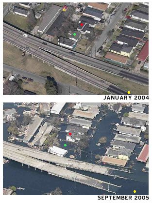
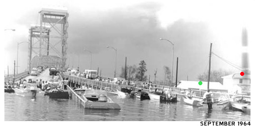
Last week I stumbled upon a slew of post-Hurricane Betsy photos on a St. Bernard Parish Government-run website. (LINK) The storm surge of Hurricane Betsy caused catastrophic damage in September 1965 in many of the same areas impacted by KTMB such as the Lower 9th Ward and St. Bernard Parish. One of the pictures I thought was especially interesting was taken (from a boat I presume) in the flood waters at the base of the North Claiborne Bridge looking back towards the bridge. Upon seeing that 1965 image, I brought up the before (2004) and after (2005) KTMB oblique shots taken by Pictometry to contrast and compare the area before and after the storm, but also to see the differences from 1965 to now. The yellow dot on the above 2004/2005 photos represent the location or point of view where the 1965 photo below was taken. The red and green dots signify the locations of the same two buildings in all three time periods. Post-KTMB, the green dot house is no longer there. Based on the distance of the water level up the slope of the bridge from its base in both the 2005 and 1965 photos, it appears the severity of the flooding was virtually the same. As the forty year old photos illustrate, to even suggest "we had no idea this could happen" is absolute uninformed nonsense.
Comments? Ideas? Email seymourdfair@gmail.com.
posted by Seymour D. Fair @ 5:30 PM
1 comments
![]()
![]()

1 Comments:
The picture that you claim as Claiborne Avenue in 1965 is actually the Industrial Canal. Claiborne wasn't constructed until the early 1970's.
Post a Comment
<< Home