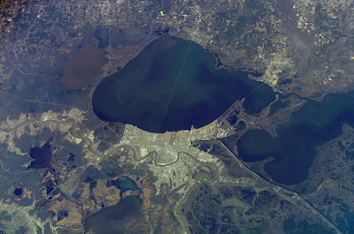
Aerials du Jour: Recent Images of New Orleans from Space
Long before Google Maps and Google Earth were introduced, the extensive catalog at NASA's fantastic The Gateway to Astronaut Photography of Earth provided plenty opportunity for me to waste hours and hours while mesmerized by tens of thousands of photographic images of the planet. Some were taken from Space Shuttle missions and some from the International Space Station (ISS). Below are some recent shots of New Orleans (link will direct to origin page where high res version can be downloaded):
 27 September 2007
The Missisippi River, Bayou Lafourche, Bayou Terrebonne, and
Bayou Teche Ridges all very apparent.
 21 November 2006
The evident spoke pattern of streets of Uptown.
Ever notice Naploeon Avenue and Barataria Boulevard have
nearly identical alignment? Hmmmm.
 26 February 2007
New earthwork can be seen along the levees along MRGO
and the Intracoastal Waterway in New Orleans East.
 26 February 2007
Imagine the further extent of damage if New Orleans East's proposed Orleania mega-development had happened in the late 1960's/early 1970's. Only half of the acreage within the levee protection system in "the East" is currently developed.
 18 November 2006
Look how wide MRGO appears in this oblique.
Not quite that wide when dug 40+ years ago.

10 Comments:
Great photos! I think the first one needs the date changed from 2007 to 2006, though.
Beautiful stuff.
I notice you put "the East" in quotation marks. You should have also put "levee protection system" in quotation marks.
Or perhaps "levee" "protection" "system."
Re: Levee Protection System = Oxymoron
Re: Napoleon and Barataria-remember the bridge proposed for that corridor as part of the Riverfront Expressway? I wonder if that had something to do with the alignment.
Looking at that 2006 photo, it's not the MRGO that I notice--it's Lake Borgne and the Gulf of Mexico I see. What you have there is a barn door-sized opening next to the mouse hole MRGO. It's pretty obvious where all that water came from.
Peace,
tim
I should specify: the 18 November 2006 photo.
Peace,
Tim
If you get time, the world awaits your comments on the ACOE's recent maps.
I once heard that more material was removed to create the MRGO than was removed to create the Panama Canal.
I'm interested in doing a link exchange with you. Please check out my blog www.storybookvacations.blogspot.com and let me know if you're interested.
Thanks.
Bryan
прикольно
Post a Comment
<< Home