One Word: Ridges
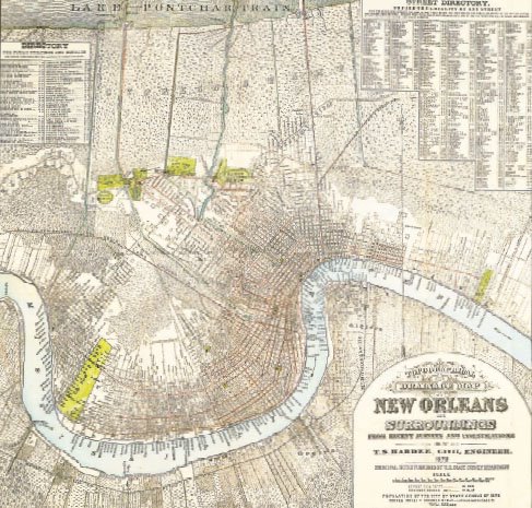
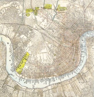
1878 Plan of New Orleans and Surroundings. Why da ain't no streets in Broadmoor, Lakeview, Gentilly, or in Da East?
In The Graduate, Benjamin Braddock was told "plastics." In a particular Seinfeld episode, Kramer had his "levels." In the case of New Orleans, the one word is "ridges."
The lead article in the 3 November 2005 Times-Picayune (LINK) discusses the realization that the areas within the City of New Orleans that flooded because of the KTMB floodwall failures and those areas that didn't flood amazingly coincide with the bounds of New Orleans before 1900. The reason for this is not rocket science: the initial extent of the City of New Orleans was relegated to the higher ground of the locale's ridges. The surrounding near or below sea-level cypress and palmetto swamps (referred to as the "backswamps") remained undeveloped as they were subject to the annual Mississippi River Spring flooding as well as sporadic flooding from Lake Pontchartrain.
Since New Orleans' location is built upon the alluvial floodplain of the Mississippi River, the elevation is highest adjacent to the River than the land further from it. As the Mississippi River water receded following the annual Spring flood, the silt and sediment siphoned into the river from 1/8th of the North American continent formed natural levees on the lands adjacent to the Mississippi River. This pattern also occurred on secondary tributaries in the area forming the Metairie Ridge, the Gentilly Ridge, and the Bayou St. John Ridge. Because of the continuous flood threat, the city's development remained on the highest ground on these ridges for nearly 200 years. In the limited areas agreeable to urbanization the population of New Orleans capped out at about 200,000.
Two separate technological advancements by the 1930s allowed growth beyond the initial ridge extents: the invention of the mechanized pump in the early 1900s and the establishment of a formalized levee system in response to the 1927 Mississippi River Spring floods. The reclamation of the backswamp lands involved pumping out the standing waters and constructing a drainage system utilizing a network of canals. The river levees kept the Spring floods contained to the river bed and the batture lands riverside of the levees. Once these two elements were implemented, expansion beyond the ridges was deemed feasible and development in the non-ridge portions exploded--especially in the FHA/VA loan-induced years following World War II.
On 9 September 1965, Hurricane Betsy passed west of New Orleans causing catastrophic flooding in nearly all portions of coastal Southeast Louisiana including a yet-to-be-subdivided New Orleans East, the Lower 9th Ward, St. Bernard Parish, Plaquemines Parish, and the Lake Pontchartrain-bordered areas of St. Tammany Parish. (Sound familiar?) During the Hurricane Betsy event, the core of the City of New Orleans and neighboring Jefferson Parish suburban slab-o-rama were luckily spared the floodwaters. Hurricane Betsy however served as a wake up call and in the following years a hurricane-protection levee system was designed and installed with the goal of withstanding storm surge flooding from another Betsy-caliber hurricane. Until the early hours of 30 August 2005 the basis of that system kept the sea out of New Orleans for 35+ years.
Not only did the levees, the pumps, and the drainage canals allow expansion beyond the ridges, the vernacular architecture specific to "Ridge" New Orleans was abandoned in the majority of the post-World War II housing construction. In terms of the flood threat, the most important element of the vernacular New Orleans tradition was raised, off-the-ground houses on bricks or pillars. The international style of blah suburban ranch house, featuring brick construction on a concrete slab became the preference--especially after 1960. The new non-ridge houses should have been built-up even higher (in some cases ten feet above the ground level--on stilts or pillars) than the pre-1950 structures, but instead were built at ground level on a slab--in areas that were near or well below sea-level.
The ugly truth: the levees and the pumps and the drainage canals provide a false sense of immunity from the realities of the flood potential in the harsh geographic setting that is New Orleans. Some of Gentilly, nearly all of Lakeview, nearly all of New Orleans East, and nearly all of Chalmette are comprised of slab houses built at grade. The pre-1950's areas that did flood post-KTMB including most of Mid City, most of Broadmoor (literally translated as "large, poor draining land"), parts of Gentilly, parts of Uptown, and parts of Carrollton mostly consist of raised houses. Many houses in these areas did receive substantial (but salvageable) flood damage taking in 2+ feet of water (which could have been 5+ feet water if not for having been elevated), however many others in the ridge-periphery areas did not get penetrated by the floodwaters because of their elevated constuction. In some cases, six inches or less of elevation off the ground was the difference between a house flooding and not flooding. Another common issue is that over the course of the last 100 years many owners of elevated houses could not resist the urge of filling-in the open space underneath their houses to form additional space in a "New Orleans" basement (including the house I live in). Many homes with this feature suffered flooding in the basement but not the main space of the house revealing that there was a reason why that space was left open 100 years ago.
The slab-o-rama houses in areas below sea level by their design absolutely had no chance with this flood--end of story. Don't even get me started on the slab-o-rama in Jefferson Parish . . . Thats for another post.
Comments or ideas to share? Email seymourdfair@gmail.com.
posted by Seymour D. Fair @ 10:00 AM
0 comments
![]()
![]()

0 Comments:
Post a Comment
<< Home