Maps du Jour: Aerial Views of Lakewood North
My friend Redtoe-3 (no, he's not a rap star) grew up in and up until August 2005 lived in the Lakewood North neighborhood--which is the residential area hemmed in by I-10 to the south, Veterans to the north, the 17th Street Canal to the west, and Pontchartrain Boulevard to the east. I recall him telling me that when he was growing up he'd find golf balls in the ground every so often as the neighborhood was developed upon the former West End Country Club golf course.
On 29 August 2005 his forty-year old, on slab house became immersed in 9+ feet of water. He and his wife have had their emotional up's and down's since August, but like Tim and his family they have overall stayed amazing positive and shown great resolve over the past eleven months. I don't know that I would handle myself as well if my home (and possessions) had been completely ruined such as their's.
The New Orleans Public Library has since the early days of the world wide web provided an "images of the month" section. Over the years, I've spent countless hours browsing the old photographs and other imagery posted on the site as there is some great, great stuff digitized and viewable online. For the August 2006 offering, the NOPL has posted digital scans of twelve aerial photographs of certain areas of New Orleans taken in 1946. One of those panels includes the area consisting of Redtoe-3's Lakewood North. First, up--a vicinity comparison using USGS 1:24,000 quad maps:
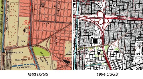
 1946 NOPL Archives:The canal on the left (the west) is the 17th Street Canal. The canal on the right (the east) is the New Basin Canal bound by Pontchartain Boulevard (then State Highway 33) and West End Boulevard. The drainage ditch splitting the land between the two wide canals demark the location of current-day Fleur-di-Lis Boulevard. The West End clubhouse seen towards the right (southeast) corner of the image is approximately the present-day location of the recently pre-KTMB constructed I-10 railroad-dip pumphouse. Woodlands affront the 17th Street Canal on the Jefferson Parish side.2004 USGS DOQ Quad: It is amazing how much land highway interchanges require. The heavy tree canopy of Southern Live Oaks denote the street pattern of Lakewood North and the portion of Lakewood South seen in this image.
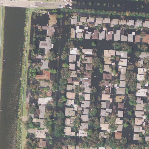 2005 Post-KTMB Aerial, Lakewood North Detail: 7 to 10 feet of floodwater sits in Lakewood North. This image was captured in the first week of September 2005.
TAGS: Katrina, New Orleans, NOLA, Lakeview, Lakewood North, GIS, Maps
posted by Seymour D. Fair @ 4:32 PM
0 comments
![]()
![]()

0 Comments:
Post a Comment
<< Home