Maps du Jour: New Orleans Relief Maps
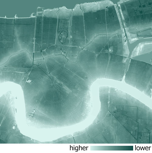 One word: Topography. These images are LIDAR-derived models of New Orleans. The darker the green shade, the lower the elevation and the lighter the green shade, the higher the elevation. The various ridges within New Orleans are quite evident in these models--denoted with the lighter shades. Most obvious is the Mississippi River Ridge, but also as noticeable are the Metairie, Esplanade, Bayou St. John, and Gentilly Ridges. Additionally, the WPA-era "filled" Lakeshore area acts as another ridge--although an aritificially created one. The ridge hemmed "bowl" areas of Broadmoor, Lakeview, Gentilly, and Old Metairie (Hoey's Basin) stand out illustrated with the darker thematic.
 CBD/Vieux Carre/Faubourg Marigny/7th Ward/Mid City. The Lafitte Corridor (Carondelet/Old Basin Canal) is slightly raised and is evident in the model. In the Sauve Crevasse Flood in 1849 the "spoil" area from the canal stopped the inundation from going any further east. In that flood event all lands between the Metairie Ridge and the Mississippi River Ridge from current-day River Ridge (i.e. Sauve Road) to the Carondelet Canal suffered severe flooding with current-day Broadmoor recieving four to six feet--which sounds quite familiar.
 Lakeview/City Park/Gentilly. The east-west railroad grade and the levee-bases of the lateral canal floodwalls stand out in this image. Also, notice the underpasses under the railroad grade at I-10, Canal Boulevard, Orleans/Marconi Drive, St. Bernard Avenue, and Gentilly Boulevard. These underpasses, despite what some have erroneously said, are the only non-drainage locations (canals and lakes) in New Orleans with elevations below ten feet below sea level.
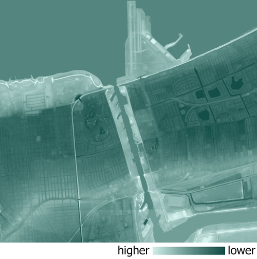
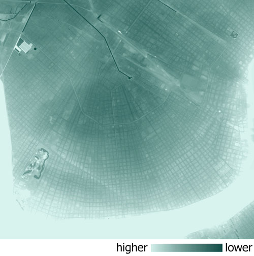 Carrollton/Fountainbleau/Uptown/Broadmoor. The spoke pattern of streets is pronounced in this image. Because the French arpent system originally divided the land along the River, the "vertical" streets were based on these property lines and run (or attempt to run) perpindicular to the Mississippi River creating the spoke pattern of streets. This pattern is evident in the above image from the Vieux Carre through Uptown to Carrollton and the Jefferson Parish line. The "bowl" area of Broadmoor is the pivot point where the geometry of this pattern of streets all culminate resulting in some unusually patterned city blocks.
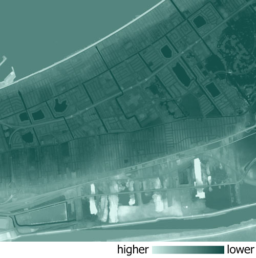 New Orleans East. The industrial portions along the Gentilly Ridge are fairly high in elevation, but the bulk of the developed areas of New Orleans East have extremely low elevations with I-10 being located in the core of the lowest areas. Notice how the land upslopes along the Lake and Haine Boulevard, but only provides two blocks of development elevation above sea level.
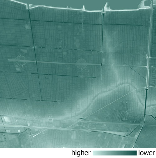 Metairie/Old Metairie. The Riverside area of Metairie Road (Hoey's Basin) is the portion of Metairie which became inundated because of the City of New Orleans floodwall failures. Notice that the darker shades (lower elevations) in Metairie/East Jefferson are not located within Hoey's Basin, but are instead everything north of the Metairie Ridge. Metairie Ridge held the water back from completely overtaking the majority of East Jefferson. The remnants of a once-tributary of the now-filled Metairie Bayou (Metairie Ridge) can be seen running northwest as a slight ridge in the general vicinity of Bonabel Boulevard.
TRIVIA DU JOUR: Which has a higher elevation? Monkey Hill at Audubon Zoo or the Civil Defense Shelter at West End? Bonus points for a guess on the elevations . . .
TAGS: New Orleans Katrina Lakeview Broadmoor Gentilly New Orleans East
posted by Seymour D. Fair @ 12:01 AM
10 comments
![]()
![]()

10 Comments:
Very interesting post.
Now, for the trivia. Since you didn't phrase the question in terms of relief (relative to the surrounding terrain) but in terms of elevation, (relative to sea level), I'll venture a guess that Monkey Hill has a higher elevation than the Civil Defense Bunker, if for no other reason than the fact that it's on the high ground along the river's natural levee. (It's pretty white on the map.) It was easy to research Monkey Hill's elevation, which is reported to be 28 feet, so I'll just guess the the CD Bunker is about 18 feet above sea level. (I don't remember it ever striking me as being very high.)
I look forward to finding out...
Those maps are lovely, made me all dreamy looking at them
Wow, Lisa is awefully close on both guesses.
BONUS QUESTION: What object located in the Lakeview area is higher than both the Civil Defense Structure and Monkey Hill (according to the LIDAR data). Extra bragging rights to the person who can guess the height of said object.
My guess- that big hill in City Park- I think it might be on Scout Island...not sure. It's a LOT higher than Monkey Hill, that much I know. The published elevation is 53 feet, but who knows how old or accurate that figure is. Since the LIDAR data is undoubtedly current and the city has a reasonably brisk rate of subsidence, I'm guessing 50 feet.
Yeah, the big pile from the excavation of the lagoons, off the traffice circle where they used to have free concerts *way* back in the day (early 70s).
Yea, Lisa. You got it right. However, the LIDAR data has the elevation at about 29 feet. I'm not sure about the 53 feet that was published, that's an awefull lot of subsidence. Where did you get that figure from?
I realize that this figure sounds rediculously high for New Orleans. The only place I could find an elevation for Laborde's Lookout was in an old Blake Pontchartrain column in Gambit.
For a non-expert like me, this is just way cool. Thanks for a great post! I don't think this kind of thing is happening anywhere else.
リノベーション
リノベーション
リノベーション
リノベーション
リノベーション
リノベーション
リノベーション
リノベーション
リノベーション
リノベーション
ビジネス英会話
英文 書き方
英語塾
社会人入試
英語 転職
医療脱毛
箱
会社設立 格安
派遣会社
東横 賃貸
田園都市 賃貸
デザイナーズ 賃貸
恵比寿 賃貸
学芸大学 賃貸
目黒 賃貸
中目黒 賃貸
新築 賃貸
ペット可 賃貸
三軒茶屋 賃貸
パチンコ求人
販売管理
債務整理 新宿
過払い 渋谷
液晶 テレビ 32
先物 比較
先物 比較
先物 比較
先物 比較
先物 比較
先物 比較
先物 比較
先物 比較
先物 比較
先物 比較
事業再生
経営計画書
経営改革
経営改善
会社分割
経営コンサルティング
お見合いパーティー 福岡
お見合いパーティー 福岡
お見合いパーティー 福岡
お見合いパーティー 福岡
お見合いパーティー 福岡
お見合いパーティー 福岡
お見合いパーティー 福岡
お見合いパーティー 福岡
お見合いパーティー 福岡
お見合いパーティー 福岡
浮気調査 松戸
浮気調査 船橋
備考調査 追跡調査 東京
不倫調査 離婚調査 東京
浮気調査 素行調査 東京
ストーカー相談 ストーカー対策 東京
結婚調査 結婚詐欺 東京
信用調査 企業調査 東京
調査料金 東京
身上調査 身元調査 身辺調査 東京
所在調査 東京
夫 妻 浮気 東京
Post a Comment
<< Home