Map du Jour: 1828 New Orleans and the Carondelet Canal
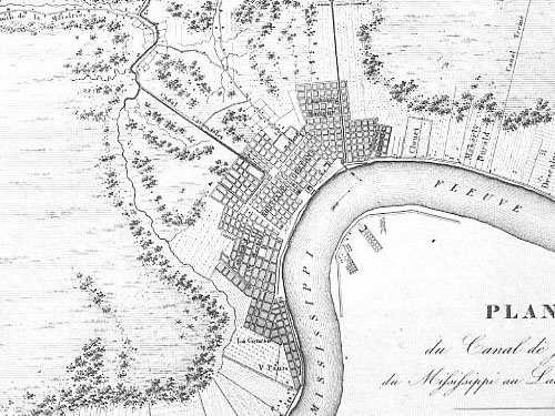
New Orleans, 1828. Faubourg Marigny, the Vieux Carre, Faubourg St. Mary, Treme, and the Lower Garden District . . . they're all there--hugging the high ground along La Fleuve. The Carondelet Canal can be seen running diagonally from the backside of the Vieux Carre (at the current-day Louis Armstrong Park) to Bayou St. John (near the current-day city vehicle inspection station near the end of Jefferson Davis Parkway) . The Carondelet Canal (later renamed the Old Basin Canal) enhanced the natural "back door" of New Orleans to Bayou St. John and Lake Pontchartrain and ultimately the Gulf of Mexico for over 130 years. In the 1930's once the maritime value of the canal was diminished, the canal was filled and the swath of land was converted to another transportation use: a railroad line. Industrial land uses and warehouses followed on adjacent properties to the corridor mid-century, but in the last twenty years those uses have waned as freight distribution shifted to trucking and away from trains. Today, the Lafitte Corridor, as it is now referred, presents a fantastic opportunity to convert a now largely abandoned right-of-way of land into a "rail-to-trail."
The routing of the corridor transverses the heart of New Orleans through Treme, Mid City, and Faubourg St. John and additionally connects with the existing greenspace along the banks of Bayou St. John. The to-be-developed Wisner Bike Path connection to Bayou St. John will potentially allow a continuous green path from Louis Armstrong Park to the WPA-"rebuilding"-era City Park to the WPA-"rebuilding" era parkspace along the shores of Lake Pontchartrain/Lakeshore Drive. The Laffite Corridor "rail-to-trail" project is a no-brainer--it will be a re-development and economic catalyst--and can be a lasting symbol of the rebuilding of New Orleans. Something is seriously flawed if this opportunity is squandered and not realized.
The Friends of Lafitte Corridor group was created to help see this project become a reality. They have established a yahoo discussion group which can be seen here. The Mid City Neighborhood Association website also periodically mentions developments of the Lafitte Corridor project. In May 2006, the 2nd Annual Lafiitte Corridor Hike was conducted to promote awareness of the greenspace potential of the right-of-way. Editor B's pictures of the event can be seen here.
TAGS: Katrina, New Orleans, NOLA, Mid City, Lafitte Corridor, Rail-to-Trail
posted by Seymour D. Fair @ 5:53 PM
5 comments
![]()
![]()

5 Comments:
Seymour,
Finally!!!!! A very productive post. This is really neat. I also think it is a great illustration of how even back nearly 200 years ago without the aid of the technology that we have today that the then city dwellers of the time realized that humans could only "engineer" nature to a certain point and that the expansion into the areas that received the truly deep water was perhaps a poor idea without the proper flood control protections. Katrina was a wake-up call to this simple fact.
By the way, could you clarify what "The Second Battle of New Orleans" was. Am I correct in assuming that it was Katrina?
I've always heard the "Second Battle" was the building of the I-10. Unfortunately it seems the Tremé neighborhood lost that one.
Great post, thanks for writing it.
The Second Battle was the fight for the Riverfront Expressway back in the 60s/70s. Some friggin' idiots wanted to put an elevated expressway right next to Cafe Dumonde. Brilliant. Seymour can probably shed a little more detail on it.
Someone finally asked . . .
The reason for the name was supposed to be the first post on the site--but I never finished writing it . . .
THE (FIRST) BATTLE OF NEW ORLEANS: Americans/Andrew Jackson defeat British in War of 1812.
THE SECOND BATTLE OF NEW ORLEANS:
College students/preservationist defeat "the Highway men" stopping the Riverfront Expressway--a network of interstate-grade roadways--from butchering the historic areas of New Orleans in July 1969.
THE THIRD BATTLE OF NEW ORLEANS: New Orleans as it attempts to exist, recover, and remain New Orleans and not become Non Orleans following the MANMADE flooding in August 2005. Ongoing . . . . The South Carrollton/South Claiborne Walgreen's affair is a skirmish in this battle.
Do you have detailed maps of the proposed project?
Post a Comment
<< Home