Map du Jour: 1828 Plan of New Orleans and Environs
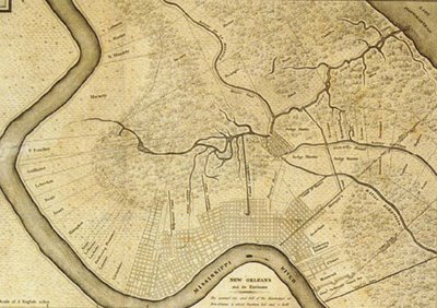 1828 Odgen Plan of New Orleans and its Environs. The most noteworthy feature of this plan is the extension of Bayou St. John from the Carondelet Canal (its current-day "headwaters" near the city vehicle inspection station) into current-day Broadmoor, Fontainebleau, and Carrollton. Clinging to the Mississippi River Ridge, New Orleans is limited to Faubourg Marigny, the Vieux Carre, Treme, Faubourg St. Mary, the Lower Garden District, the Irish Channel, and the Garden District. The Bayou Road travels from the Vieux Carre to the development centered on Grand Route St. John situated on the high ground at the junction of Bayou St. John and Bayou Gentilly--the current-day neighborhood riverside of The Fairgrounds. In this view, the "Creole St. Charles" Esplanade Avenue has not yet been extended beyond the Quarter towards Bayou St. John and the Marigny Canal demarks the future location of Elysian Fields. Also, the arpent-based property lines running perpendicular from the Mississippi River can be seen from the the edge of the built city (current-day Uptown) upriver to Carrollton.
 2004 LIDAR-derived Elevation Map. With the approximate extents of the 1828 plan above, this elevation map illustrates the ground elevation in 2.5 foot increments. The green and purple thematic are those areas above or at sea level and the cyan, yellow, orange, and red thematic displays ground elevations below sea level--with the orange and reds being the lowest spots. The locations of Bayou St. John, Bayou Metairie (now filled--except for the City Park lagoons near City Park Avenue), and Bayou Gentilly (now filled) in the 1828 plan are clearly visible as current-day high ground ridges. The sea-level ridge in which Carrollton Avenue transverses from Claiborne to roughly Palmetto explains why the flooding along this portion of Carrollton Avenue was not as deep as adjacent areas such as Gert Town, Hollygrove, Pigeon Town, and Broadmoor. The Esplanade Ridge (the location of Esplanade and Bayou Road) and the raised ground of the Lafitte Corridor (former location of the Carondelet Canal and railroad right-of-way) are also evident in the elevation model.
TAGS: Katrina, New Orleans, NOLA, Bayou St. John, Maps, Lafitte Corridor
posted by Seymour D. Fair @ 12:47 AM
3 comments
![]()
![]()

3 Comments:
The high ground generally follows the natural levees of the old bayous, which were later filled an replaced with major avenues.
Hi,
I am a graduate student of Architecture and Urban planning at University of Toronto Canada. I have been looking around to find a higher resolution of the historic map of Bayou St. John, but I haven't got much luck.
I was wondering if any of the contributors of the blog could help me out or direct me to a source where it is from.
my email is : safora.khoylou@utoronto.ca
I highly appreciate your help and time.
Safora Khoylou.
You don't happen to have a higher res version of the 1828 ogden plan do you? If you do, would you mind sharing it with me, such that I can georeference it. Please feel free to email me at rwaldron at g m a i l
Post a Comment
<< Home