Times-Picayune: Flooding Timeline/Interactive Map
Bob Marshall in Sunday's Times-Picayune provides a timeline of the flood protection system failures that lead to the inundation of New Orleans, Old Metairie, St. Bernard Parish, and Plaquemines Parish.
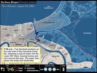
Also included is a nifty interactive map (a flash animation) that illustrates the flooding by time increment.
What's amazing to me is that none of the flooding within the City of New Orleans was officially stated by the media until the early hours of Tuesday, 3o August. The timeline states all flooding was underway by 10:30am on the 29th, the day of KTMB landfall. From my evacuation location in Colfax, LA, I recall feeling pretty confident about the flooding situation within New Orleans in the afternoon of the 29th based on what was stated online, on the radio, and on television. In reality, the place was drowning.
Some points from the article:
The costliest natural disaster in the nation’s history began early Monday, Aug. 29, with a small leak near the Interstate 10 High-Rise about 4:30 a.m. and climaxed with the horrific collapse of floodwalls along the 17th Street and London Avenue canals between 9:30 and 10:30 a.m.
Researchers now say as many as 30 breaches in the system accounted for 84 percent of the metro area flooding, with most of the water coming from the big gaps along the 17th Street, London Avenue and Industrial canals, as well as holes in the Mississippi River-Gulf Outlet and Gulf Intracoastal Waterway levees and a gap in the Orleans Avenue outfall canal that flooded much of the City Park area.
St. Bernard Parish: 89 percent of the flooding came through breaches in the MR-GO levees on the eastern side of the parish and from the Industrial Canal, also called the Inner Harbor Navigational Canal, on its northern end.
Eastern New Orleans: 63 percent of the flooding came from breaches along the Gulf Intracoastal Waterway and the Industrial Canal.
The rest of New Orleans: 87 percent came through the holes in the 17th Street, London Avenue and Industrial canals, as well as the gap in the Orleans Avenue Outfall Canal.
Read the full article.
TAGS: Katrina, New Orleans, NOLA, Flooding, 17th Street Canal, St. Bernard, New Orleans East
posted by Seymour D. Fair @ 9:35 PM
6 comments
![]()
![]()

6 Comments:
This is one of the best graphics I've seen.
Incredibly upsetting too.
Makes me fantasize about taking a GoodFellas approach to the Corps.
Hi. I found your blog only yesterday and enjoy reading it. I grew up in New Orleans and have a great affinity for the city.
I have what I hope you won't think is a silly question...what does KTMB stand for? I'm going to guess Katrina, but what about the rest?
Thanks.
KTMB equals:
Katrina That Miserable Bitch.
Theres a back story to that--but thats what it means. I had a link to the post that explains it on the sidebar but in doing some redesign (that I never finished) I never put it back up.
Thanks for asking . . .
That graphic makes me nauseaus every time I look at it. Its so chilling.
6.6ah New PA3536U Battery for Toshiba Satellite P200 P205 laptop battery
Amazing graphic.... i'm tryinig to re-find it. Any help? Links all come back 'not available'.
Post a Comment
<< Home