The Times-Picayune: "Levee System Along River Held Its Ground In Storm"
 Map from The Times-Picayune
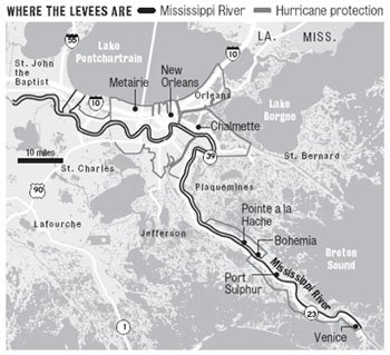
 From today's Times-Picayune: http://www.nola.com/news/t-p/frontpage/index.ssf?/base/news-4/1137999658140350.xml
The key point from the article:
"After the 1927 flood, the nation made a commitment never to let that happen again, so the design criteria (the corps) had was for the worst that could ever happen -- something that might not occur again for 400 to 450 years," said Al Naomi, a senior project manager at the New Orleans office. "In some (areas) the (river) levee was overbuilt, but that was done because the design criteria we were given was to build for the maximum possible flood.
"That wasn't the case with the hurricane protection project here."
The 1965 congressional authorization for the Lake Pontchartrain and Vicinity Hurricane Protection project was based on what the corps described in its 1962 planning document as the "standard project hurricane," which would have maximum sustained winds of 100 mph in a radius of 30 nautical miles, and a storm surge of 11.2 feet on the south shore of the lake. That translates approximately into a fast-moving Category 3 storm. The report said the probability of that occurring is once every 200 years.
There ya go . . .
posted by Seymour D. Fair @ 9:43 AM
2 comments
![]()
![]()

2 Comments:
I think the difference is that the Mississippi River levees were build years ago when the Gulf Coast of Louisian was far less populated. The more densly packed areas of today make building the wide levees that survived so well difficult as people prefer to keep their property and want narrower levees. This is what we saw with the 17th St. Canal and the London Ave. Canals.
But the authorities are not totally without fault. They went along with the public's wishes not wanting to give up the tax revenue that comes with more and larger private property.
If the people really want Cat 5 levees, many will have to be willing to let go of much of their property. We'll see what happens when the shit finally hits the fan.
Yes, the built-up densities along the 17th Street, Orleans Outfall, and London Avenue Canals prevent the large earthen berm levees like on the Lakefront and on the River. However, if gates (with the capacity to have runoff water pumped over or through them) are installed at the mouths of these canals not allowing the canal levels to rise with the Lake in a hurricane-related storm surge, properly built walls along these drainage canals should suffice.
Post a Comment
<< Home