Map du Jour: St. Bernard Parish Wetland Loss, Compliments of MRGO


 Souce: USGS 1:24,000 Chalmette Quadrangles (1953, 1968, 1980, current version)
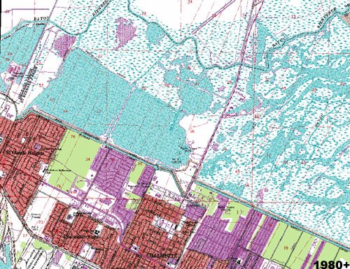
The maps above display the identical portion of St. Bernard Parish centered on Paris Road beginning in 1953 and illustrate the landscape transformation in the Chalmette area over the past fifty years. The two most apparent changes over time:
1. The increased urbanization upon the Mississippi River Ridge contained on the high ground side of the Florida Walk and Forty Arpent Canals and;
2. The metamorphosis of tree-covered swampland and vegetated marshland to open water and the widening of existing bayous and water features because of erosion.
The increased runoff from a more urbanized and less-forested Chalmette likely contributed to the destruction of the adjacent swamps and marshes, but the majority of blame centers on saltwater intrusion from Lake Borgne and Breton Sound in the past forty years. The Mississippi River Gulf Outlet (MRGO) opened in 1965 (not within the view above, but to the north of these extents) along with the maze of oil and gas industry pipeline and service canals have facilitated the intrusion of saltwater into inland wetlands killing the freshwater-based vegetation leading to massive, unprecedented erosion. The loss in turn minimizes the buffer effect healthy vegetated wetlands provide to vulnerable places like Chalmette as they provide a natural obstacle to slow down and subside a powerful storm surge created by a hurricane. Today's "buffer area" in coastal St. Bernard Parish is no where near what it was for Hurricane Betsy or Hurricane Camille in the 1960's.
In addition to enabling saltwater intrusion, MRGO provides an unobstructed path for hurricane-related storm surge to funnel directly into the Inner Harbor Canal which is exactly what happened in August 2005 subsequently flooding Bywater, the Lower 9th Ward, and subsequently Arabi and Chalmette.
Even before KTMB, the general consensus was that the digging of the MRGO (and the Gulf Intracoastal Waterway in New Orleans East) along with the oil and gas field canals scaring the entire Louisiana coastline represent extreme, nearly irreparable environmental mistakes. An additional insult to injury--the economic impact of MRGO projected during its planning in the late-1950's never materialized over the past forty years.
A nearly identical (timebomb) situation to the MRGO from the erosion/saltwater intrusion, the unfulfilled projected economic impact, and the "funnel" effect of storm surge angle is the Houma Navigation Channel in Terrebonne Parish. The presence of oil and gas field and pipeline canals dug over the past sixty years since the inception of mineral extraction in the state are even more pronounced than in St. Bernard Parish. These factors--plus its location between the current Atchafalaya and Mississippi River Deltas--lead to Terrebonne Parish (along with Lafourche Parish) having the worst coastal erosion problems in Louisiana.
The Close the Mississippi River Gulf Outlet Now (a non-profit organization established before KTMB) website gives a good summary of MRGO's problems . . .
posted by Seymour D. Fair @ 5:25 PM
1 comments
![]()
![]()

1 Comments:
A片,A片,成人網站,成人漫畫,色情,情色網,情色,AV,AV女優,成人影城,成人,色情A片,日本AV,免費成人影片,成人影片,SEX,免費A片,A片下載,免費A片下載,做愛,情色A片,色情影片,H漫,A漫,18成人
a片,色情影片,情色電影,a片,色情,情色網,情色,av,av女優,成人影城,成人,色情a片,日本av,免費成人影片,成人影片,情色a片,sex,免費a片,a片下載,免費a片下載
情趣用品,情趣用品,情趣,情趣,情趣用品,情趣用品,情趣,情趣,情趣用品,情趣用品,情趣,情趣
A片,A片,A片下載,做愛,成人電影,.18成人,日本A片,情色小說,情色電影,成人影城,自拍,情色論壇,成人論壇,情色貼圖,情色,免費A片,成人,成人網站,成人圖片,AV女優,成人光碟,色情,色情影片,免費A片下載,SEX,AV,色情網站,本土自拍,性愛,成人影片,情色文學,成人文章,成人圖片區,成人貼圖
情色,AV女優,UT聊天室,聊天室,A片,視訊聊天室
Post a Comment
<< Home