Photos du Jour: "Down the Bayou" in Terrebonne Parish
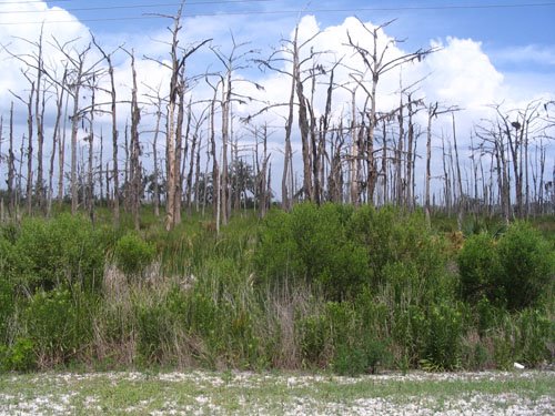
Falgout Canal Road, Dularge. Saltwater intrusion-fried cypress stands courtesy of the Houma Navigational Channel (HNC) is illustrated above. The HNC is a similarily ill-conceived canal as the Mississippi River Gulf Outlet (MRGO) dug in the early 1960s which gives the City of Houma (30+ miles inland) direct navagable marine access to the Gulf of Mexico. Just as the MRGO has acted as a conduit for saltwater intrusion and massive wetland loss in St. Bernard Parish, the HNC has done arguably even worse damage to the inland swamps and wetlands of Terrebonne Parish.

Co-Co Marina, Cocodrie. Since I was a kid, my family would take the ride down to Co-Co for lunch or dinner on special days like birthdays or like two weekends ago--Father's Day. Co-Co's claim to fame is its charter fishing excursions, but the food at the restaraunt is quite good. Yesterday I went with "The Islander" which is their large fried seafood combination--oysters, shrimp, fish, and a softshell crab. During Hurricane Rita in September 2005 the water level rose about six feet above its normal level. Major damage was sustained to the marina in August 1992 during Hurricane Andrew's landfall about 50 miles to the west in St. Mary Parish.

Co-Co Marina, Cocodrie. Manufactured in Grenoble, France, MART (Mississippi Area River Transit) car #53 has seen better days--the car has probably been underwater multiple times over the past 15 or so years based on its location. The MART (often referred to as the "gondola") was the lift constructed over the Mississippi River for the 1984 Louisiana World Exposition (World's Fair). I remember in the late 1980's/early 1990's when these cars were auctioned off after the MART was disassembled. I can recall seeing several of them in backyards around Southern Louisiana being used as greenhouses. Unforuntate that the MART couldn't persist as a viable transportation/commuter alternative beween the CBD and Algiers Point/Westbank.
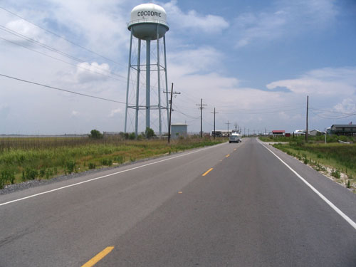
The Cocodrie Water Tower, Cocodrie. There are four main ridges or four "down the bayous" that radiate from the high ground of Houma down towards the ever-enlarging inland bays and ultimately the Gulf of Mexico. From west to east they go Dularge, Dulac, Chauvin/Cocodrie, and Montegut/Bourg. Each has its own character and worthy of exploration. Want a good day trip from New Orleans that will bring you to another world? Check out these communities before erosion or a future hurricane make them resemble what similar communities in St. Bernard and Plaquemines Parish look like post-KTMB. This water tower is significant in that is used as a site marker for boats coming back inland from offshore as it can be seen for at least ten miles away on a clear day and is the tallest structure around.


TAGS: Katrina, New Orleans, NOLA, Terrebonne Parish, Cocodrie, Houma Navigation Channel, Sign
posted by Seymour D. Fair @ 8:00 AM
3 comments
![]()
![]()


3 Comments:
test
The photo of the cypress trees along the HNC near Falgout Canal is very sad, but their deaths are likely NOT the result of saltwater intrusion. DNR and Univerisities have done numerous studies and implemented several restoration projects and modifications in that area, and have found that most cypress swamp dieback in the Barataria-Terrebonne estuary is likely due to the high rate of subsidence in the area. Basically the trees drown because they are sinking before increased salinities can kill them. The HNC and associated spoil banks could exacerbate the localized subsidence and be partly responsible, but realistically, that area of Terrebonne Parish has some of the highest subsidence rates in coastal Louisiana.
I was down in Cocodrie this week on a visit to LUMCON. My first time down that far. I was checking out the houses too, making notes about what looked damaged and what looked like it survived the windy weather. Hard to believe anybody lives down that far...
Peace,
Tim
Post a Comment
<< Home