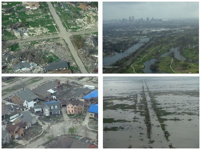
Aerial Photographs of New Orleans and Environs: 11 March 2006

Last weekend a friend of mine had the opportunity to participate in an aerial survey of the New Orleans area. Fortunately he took a boatload of digital pictures. The images capture both the widespread devastation to the built environment (still remaining over six months later) as well as the devastation to the surrounding natural systems (massive erosion/wetland loss) worsened by the storm surge.
Areas included in the images are: St. Bernard Parish (Chalmette, Arabi, Delacroix), the Lower Ninth Ward, New Orleans East, City Park/Bayou St. John, Chef Menteur/Irish Bayou, and Eden Isles/Oak Harbor on the St. Tammany Parish Northshore.
The New Orleans and Environs flickr photostream can be seen here.

0 Comments:
Post a Comment
<< Home